They've already built the bunker
Is Donald Trump building a bunker under the ballroom for himself?
In my opinion, no. Relying on the words of a self-aggrandizing, potentially senile, and increasingly paranoid man is a fool's errand. It does not explain why courts have permitted "security-related" underground construction to proceed and it does not explain why Congress has repeatedly made major appropriations to fund a similar—and equally vague—scope of work. No, a wealth of credible evidence shows that whatever secure facility is under construction at the White House is only one component in a vast and decades-old continuity of government project begun after the September 11th attacks.
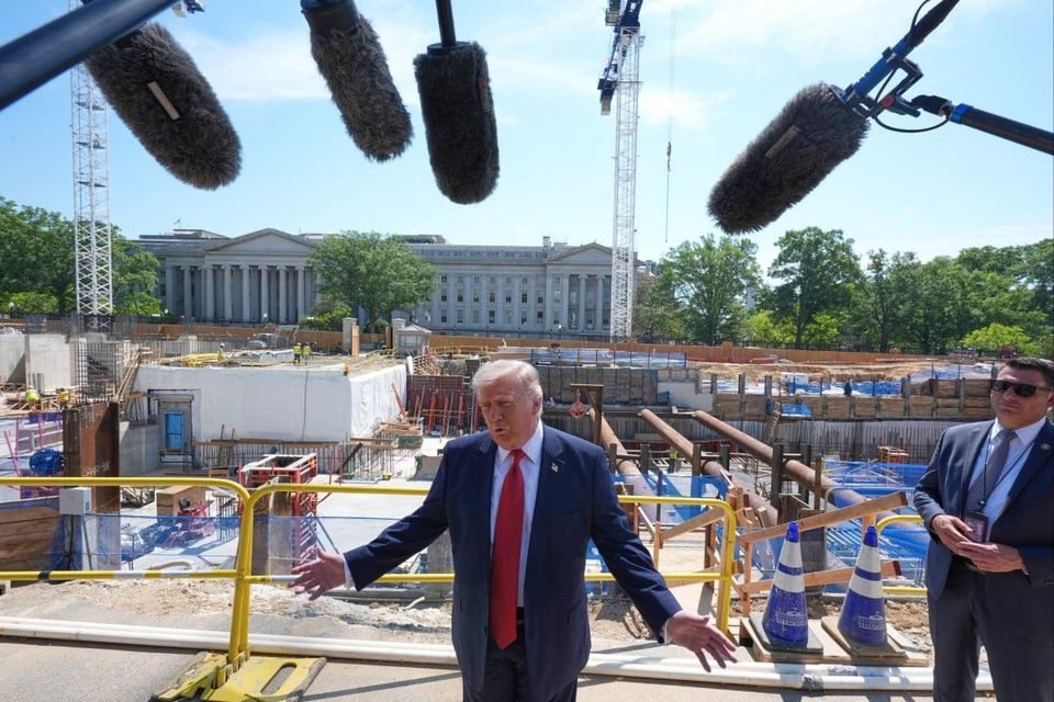
Proof of it is visible in the image at the top of the page, just to the side of the President: an opening in an "exterior" foundation wall.
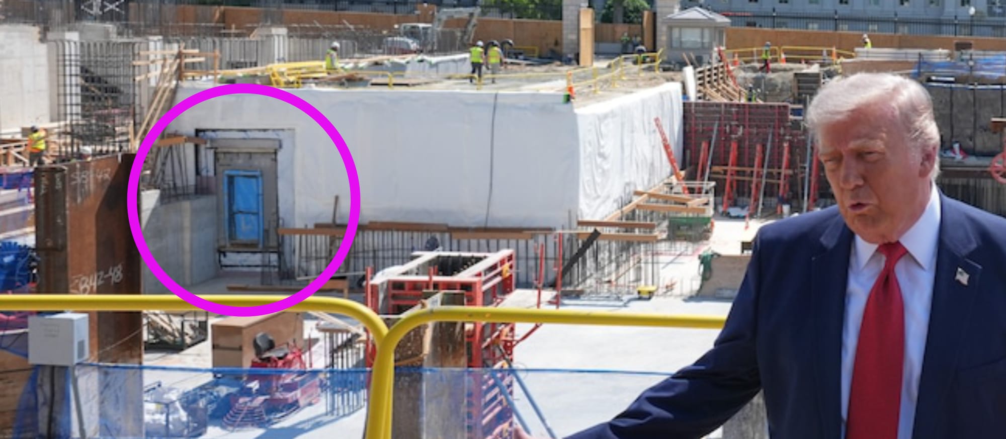
Whatever is on the other side of that aperture is known in Federal planning circles. Its scope and extent are left to rumors, but its existence is accepted with a wink. Washington is a town full of secrets. Indeed, the version of the East Wing that Trump tore down was itself built to conceal a secret: the construction of the compound's original bunker. Why would its replacement be any less clandestine?
Built by FDR at the beginning of World War II, the old air raid shelter was not actually under the old East Wing. Rather, it sat under shrubbery just to the south of the modest neoclassical pavilion. Over the years and several renovations, the facility was renamed the Presidential Emergency Operations Center. It is where Trump himself reportedly spent the evening of May 29th, 2020, after the George Floyd protests surged against the White House fence. Visitors frequently reported that the space was cramped and shabby. More importantly, DC's obsessive culture of security is never satisfied. Consequently, plans to modernize the PEOC have followed every major crisis, including more outlandish plans like the 1960s nuclear-resistant Deep Underground Command Center, or DUCC.
The thing is, there is good evidence they did build something like the DUCC, and the press reported on it. In fact, one of Trump's buddies, conservative journalist Ronald Kessler stated in a 2018 book and also in interviews, that a new bunker facility was completed at the end of the Obama presidency and that Trump has toured it. The media, for their part, treated this new structure with a wink and a nod: an open secret among the "savvy." After all, the White House Press Corps had watched it get built right under their nose, or rather their feet.
What I hope to show in this post is that they were mistaken: the huge mess that they saw in the 2010s was a noisy misdirection for a much, much bigger project. Now that Trump is claiming credit for the bunker, the attention on this new component may only bury the larger whole beneath the hole. The way in is that curious door in the ballroom's foundation wall.
ETA 8/23/26: The Washington Post has confirmed the central claim I make in this article: there is a secret bunker deep underneath the White House. I will continue to track the story as it unfolds and post addenda at the end of this post.
9/11 framed the problem
DC came to a standstill on September 11th, 2001. Roads were closed. The metro was shut down. I remember watching long streams people in business attire walk by my school as I waited to be picked up. Driving was even worse, with rush hour traffic colliding into school pickup, emergency closures, and people just trying to get out of town. According to later reporting, security agencies felt this gridlock proved it would be difficult to evacuate the President in either a conventional or terror attack. The President would have to shelter in place.
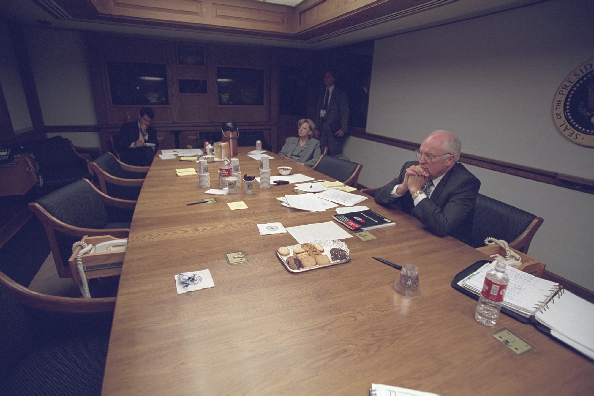
So began a new round of top-secret planning to ensure on-site continuity of operations at the White House. What the complex faced was a problem basically every community in the US deals with: it had obsolete infrastructure. This is what officials told the press in 2010—and you know what, I think it's true. It's just that sometimes the best way to conceal something is to tell the truth about something else, especially if it hogs all the attention. This is what I believe happened with something known as the "White House Big Dig."
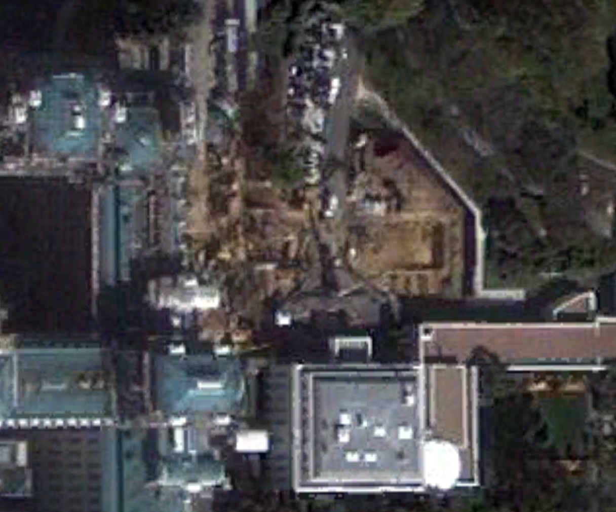
The Big Dig was a construction project that extended across the White House complex. Beginning with scattered utility work in 2004, it culminated in 2010 with the excavation of a very large hole on the north side of the West Wing. The work garnered national media attention because it temporarily displaced "Pebble Beach," a paved part of the North Lawn where TV journalists report to camera. Then, in 2012, the lawn was restored as if nothing had ever happened.
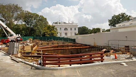
In the interview above, Kessler says that this was the new facility, despite never visiting it. Writers who have covered the topic have accepted his claims. However, I have never seen a photograph of the excavation that looks as deep as would be required. High-resolution images of the excavation are hard to come by but there is enough information in photo above to understand why. The key is the temporary walls use to retain the soil and landmark buildings, known as shoring. This kind of shoring consists of steel "soldier" piles driven into the ground. As workers excavate the hole, they slot wooden boards horizontally between the piles, known as lagging. The industry standard is to space the soldier piles 6'-8' apart. The other thing to note is that there seems to be only one level of the horizontal steel tubes, which are known as struts. (You're going to want to remember these terms.)
Kessler alleged that the new facility was "five stories" below ground, around 50 or 60 feet in depth. Assuming the standard pile spacing, however, we see a hole that is 20-30' deep. Moreover, it's common to have multiple levels of struts in excavation beyond one or two stories. We see just one. So, they certainly built something there, but the critical dimension doesn't match the description. Similarly, the dates don't line up. The northwest pit's 2012 completion date comes in the middle of the Obama presidency, not the end.
I think a clue to what Kessler was actually talking about was actually right down the street. While the press corps was joking about the hole in front of their eyes, they weren't talking about the shed on West Executive Avenue.
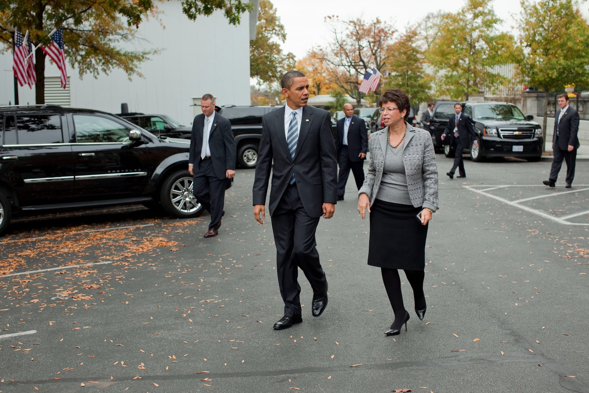
Two sheds, united in mystery
In the sequence of Google Earth historic aerials below, we see the site before construction in 2005, at the beginning of the Big Dig in 2010, and then after it had wrapped up in 2013. Notice the two structures that appear south of the East and West Wings.
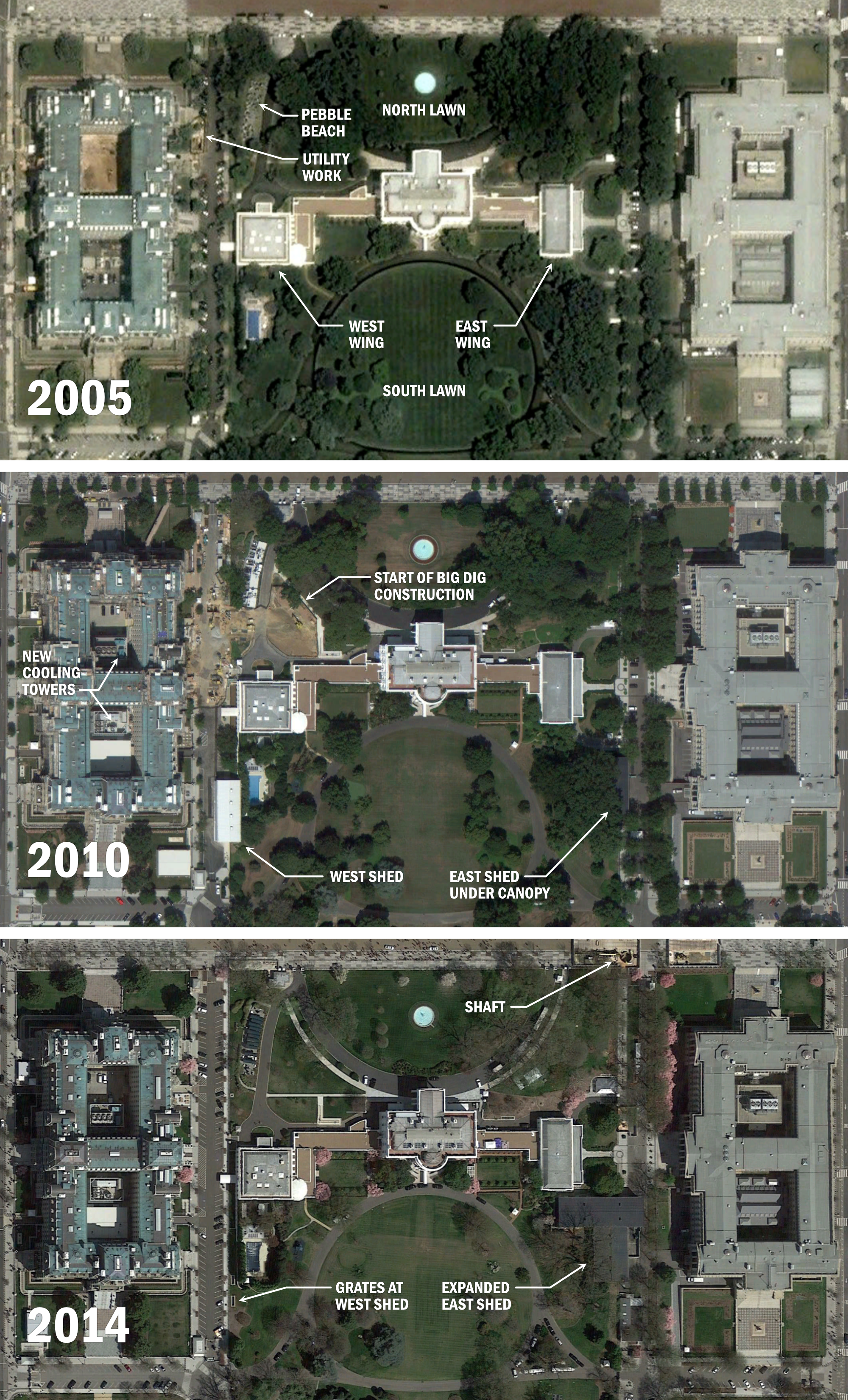
If you go and check this out yourself, you will see that the shed on West Executive Avenue appears in late 2007 and wraps up around the same time as the Big Dig in 2012. This is the one in the photograph above. You will also see a shed on East Executive Avenue. This one appears sometime before 2007, doubles in size in 2013, and then is gone by the spring of 2016—i.e. the end of the Obama administration. You can also see a lot of utility work going on around the complex, as claimed. Two large cooling towers appear in the courtyards of the Eisenhower Executive Office Building, which seem related. Now, maybe google is just busted, but I can only find the sketchiest discussions of these shed structures or the scope of the extensive utility work that led up to them.
In the absence of anything else, let's look at aerials more closely.
The West Wing shed
South of the West Wing is a semi-buried structure with a green roof, containing the Navy Mess and the White House Situation Room. It was originally built by FDR as part of his renovations to the West Wing, and initiated the Federal Government's rich tradition of stuffing things underground instead of admitting that its needs have grown. The Situation Room is both a specific room and also a suite of support spaces and personnel. This suite was renovated and expanded between 2006 and 2007, including major expansions. South of this structure is the White House's swimming pool. Built in 1975, it was renovated abruptly in 2002. The poolhouse actually appears to sit on top of the Situation Room suite and supposedly has an access stair to below so the president slip in for a dip discreetly.
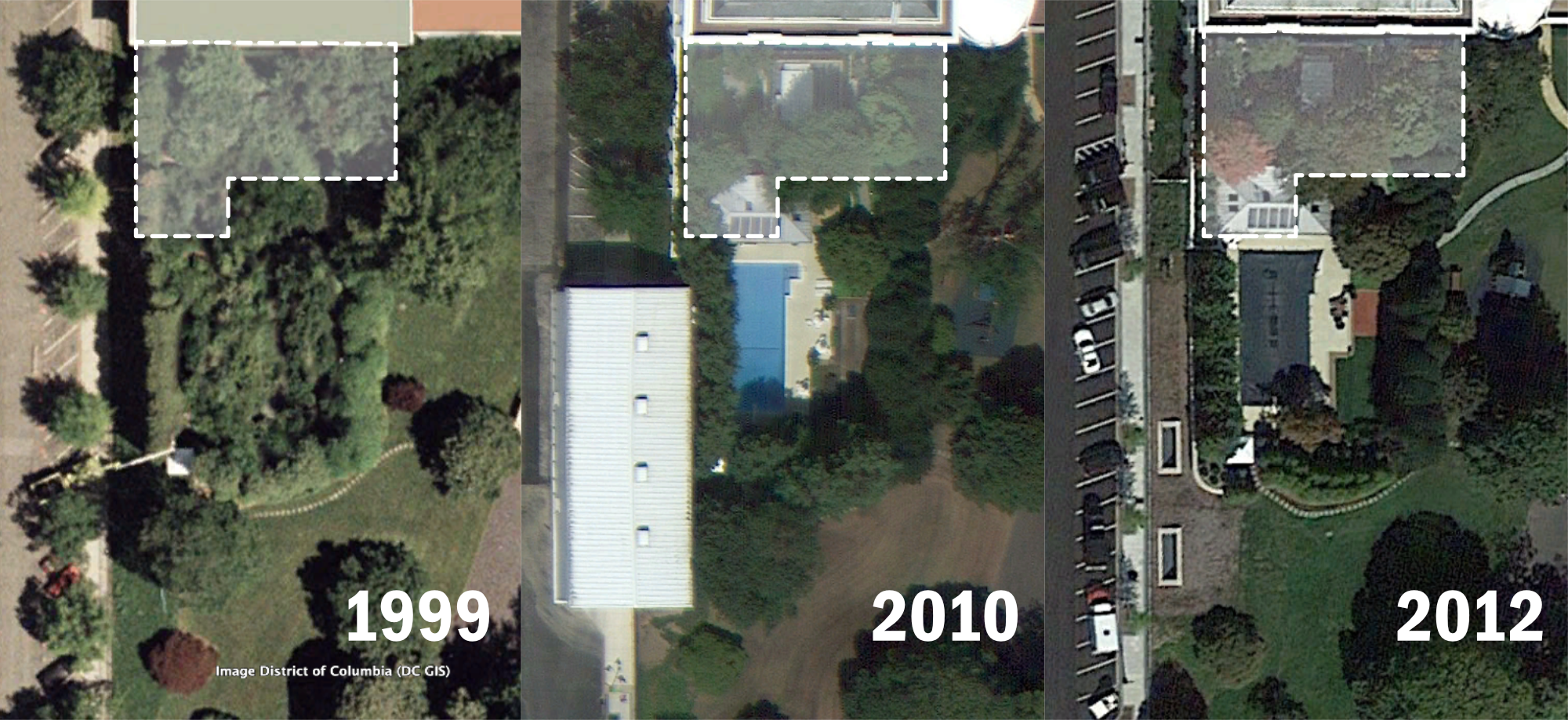
If we look at the aerials, we can see the white shed structure appear around the time of the Situation Room renovation in 2007. It similarly appears to touch the retaining walls of the pool that was rebuilt in 2002. After it disappears, two grated structures remain. These are probably a kind of ventilation shaft that we call "areaways" in architecture. Some kind of infrastructure was built in this location at this specific time, and it was more sensitive than the rest of the infrastructure work around the White House, which was conducted using ordinary pits and trenches.
The East Wing shed(s)
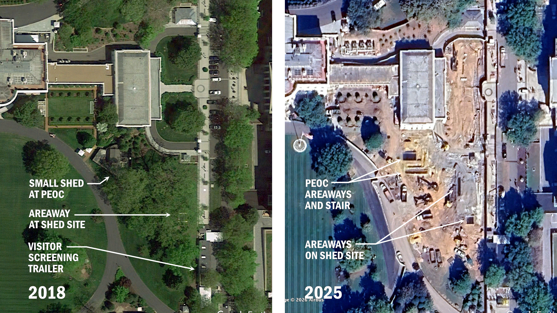
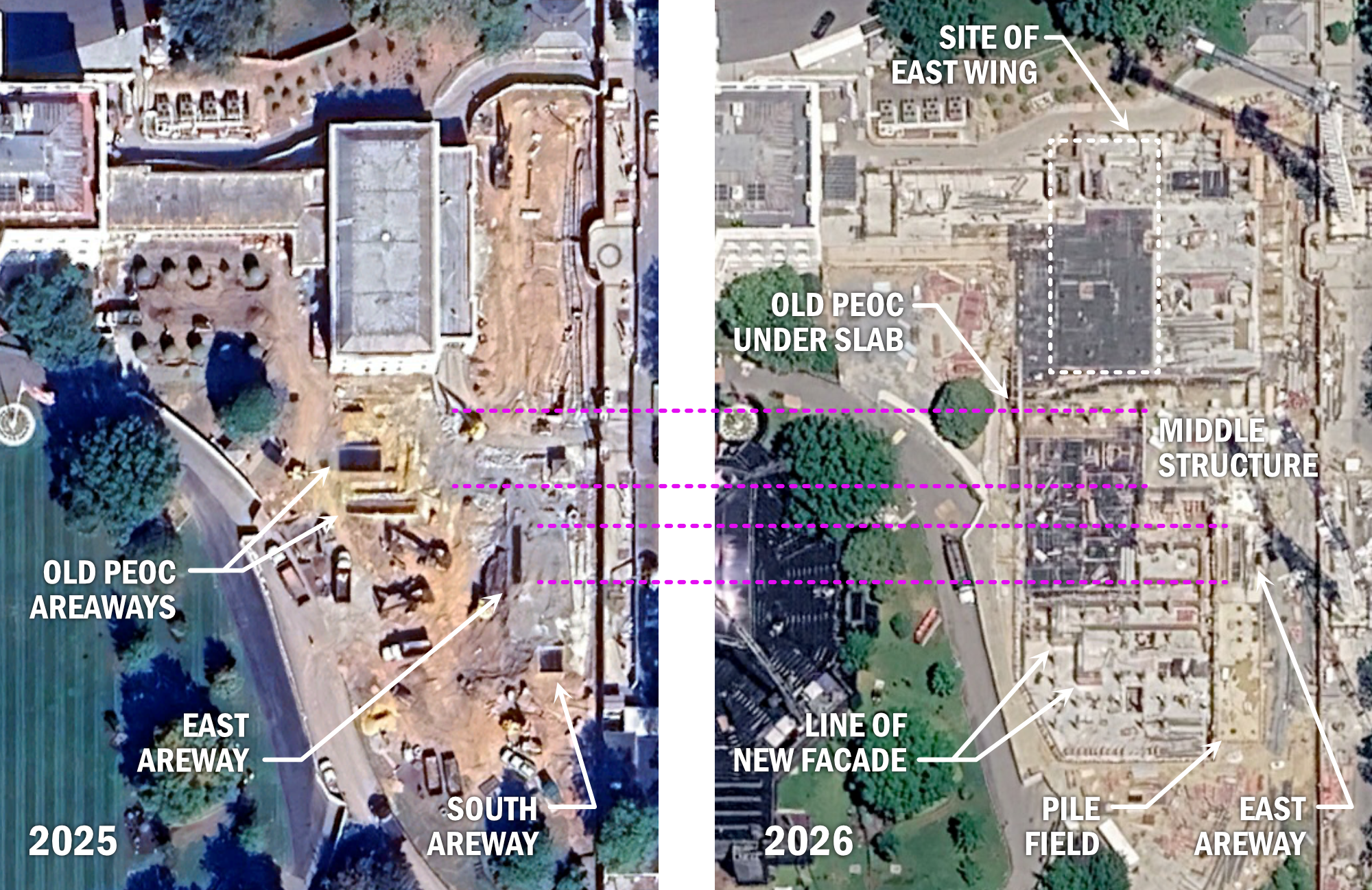
Almost directly across the South Lawn stood the east shed, with its 2007 and 2013 phases. Its expansion is very interesting, since the structure extends to the area directly south of the former East Wing where the PEOC sat. Excavation in 2026 confirmed the location, but even before then it was possible to place it through dark rectangles—probably stairs or areaways. I have highlighted those openings in magenta. These surface structures show up in the earliest imagery available on Google Earth and even the Historic American Buildings Survey, and are very visible in 2025 after site preparation began.
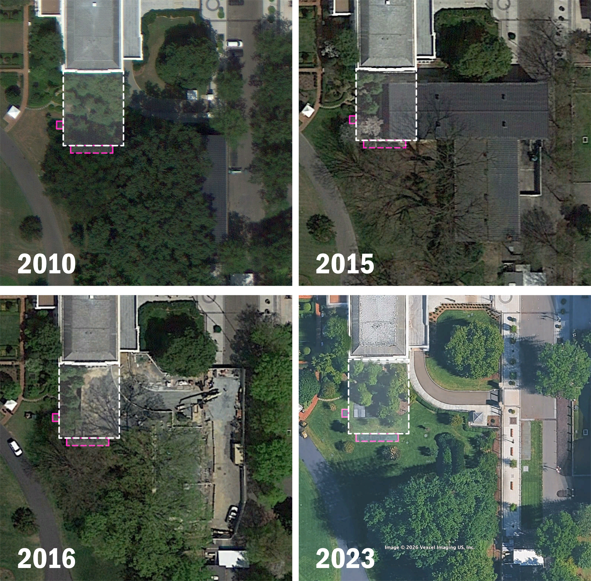
It's very interesting that the east structure is dark-colored, unlike the one on the west side. I suspect this is because East Executive Avenue, the locked-off street between the East Wing and the Treasury Building doesn't get much press attention. In fact, I have been unable to find photos down EEA from the Bush and Obama years. In contrast, Presidents regularly embark and disembark from their motorcades on West Executive Avenue (as in the photo with Obama above), so it gets a lot of press coverage. It's possible officials simply decided they couldn't hide the west structure, just like they couldn't hide the Big Dig hole. On the East Side, closer to the PEOC, they clearly wanted to be more discreet.
The same level of discretion was followed for work that appears to happen atop the PEOC between 2017 and 2020. It could be landscaping, it could be repairing the PEOC's waterproofing, or it could be something more substantial. Either way, the two sheds on the east side left evidence in the ground. Then, the construction of the new ballroom exposed tantalizing clues.
A ship that leaks from the top
Unfortunately, discretion is not one of Donald Trump's skills. Bypassing federal planning procedures, bragging about the new bunker's features, and even rambling before the press in front of the site, he has brought a lot of attention to facilities that previous administrations have fastidiously avoided discussing. But maybe all of that attention is just fine for the White House Military Office. If people are talking about his "drone empire," then they're not talking about the various oddities that are visible all over the construction site, like our friend Mr. Door.
An outline
If you're not familiar with deep excavation, it may not be obvious how strange the hole they dug was. Let me explain. For structural and waterproofing reasons, foundations generally want to be as simple as possible. Shifts in and out or up and down add major complications and risks, thus costs. This is especially true when using multiple kinds of foundation systems. Faced with a relatively rectangular building like the Ballroom, a good foundation design would entail a rectangular shape—unless tough geological conditions or existing underground structures forced them to build otherwise.
Well, a weird, complicated foundation is exactly what we see in aerial imagery acquired by ABC on May 28th, 2026. On the north side of the construction site, the the outlines of the foundation are relatively clean, closely matching the footprint of the Ballroom. On the south side, however, the line of excavation jogs in and out, plunges deeper, and mixes systems. Even the temporary shoring is fairly complicated, showing large steel struts across the excavation area. Constructors try to avoid these, as they interfere with earthmoving equipment and hoisting. But we will talk about those, as well as the intriguing angle at the southwest corner, later. For now, let's focus on the shape of the area that has been left unexcavated.
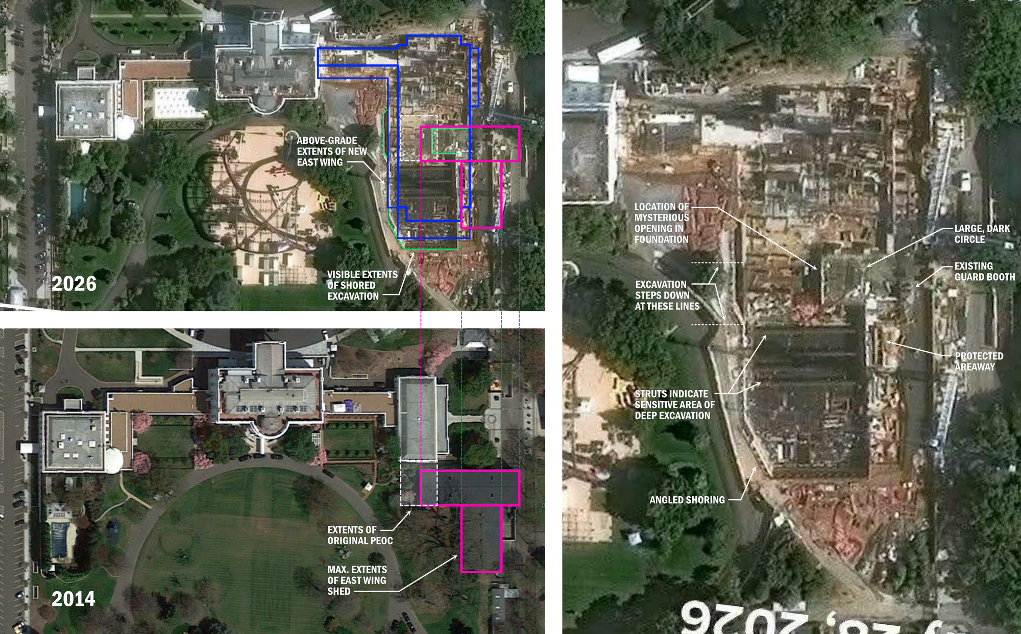
As you can see above, the east side line of excavation roughly corresponds to the footprint of the east sheds. More importantly, that mysterious opening that hovered behind the president seems to lead directly into the most pronounced jog of "unexcavated" area, right in the middle of the building.
When we look at a photograph of this structure taken from the Washington Monument in early March, when excavation was in full swing, we see some revealing details. First are the large cast-in-place concrete piles required to support the enormous and opulent ballroom. Standing prominently along the southern part of the unexcavated strip, none are present in footprint of that middle structure. Although employing the same standard shoring as the rest of the pit, its steel soldier piles are significantly rusted. Similarly, the lagging has totally rotted out. This is a structure that has been in the ground for a long time, perhaps, say, 10 years.
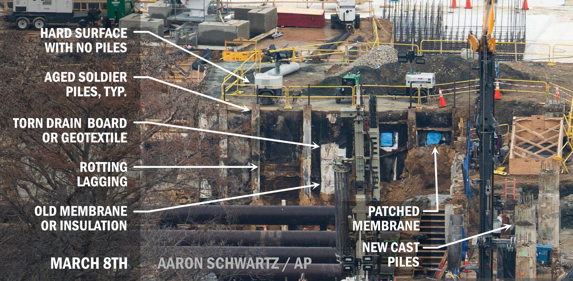
We can also see from the photograph that this is not just unconditioned utility space, like a sewer. Between the solider piles are the components of a "blind" waterproofing assembly, that is, one that is installed entirely from within the pit and same as what was put in for the new structure. Specifically, we can see a torn black drainage board or geotextile hanging in front of a white polymer waterproofing membrane. The membrane that has been touched up with the same fresh-looking Blueskin asphalt-polymer membrane as the mysterious door. Based on their shallow depth below surface, I suspect these patches were penetrations for in-ground utilities.
Out with the old?
The location of the mystery opening also offers clues to its purpose. For one, it's directly next to the old PEOC. I assumed, when I first saw it, that the passage led directly into the old air raid shelter, which had been demolished. However, if we compare images of the area from December 2025 and March 2026, we see something subtler.
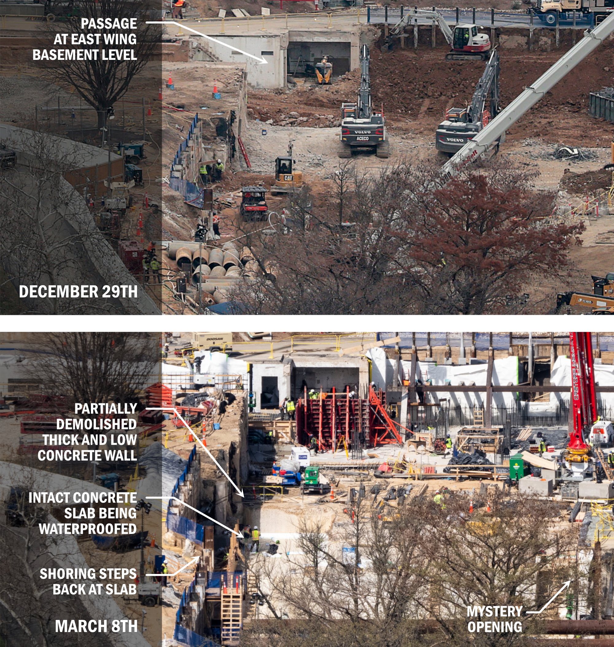
In the March image, we see workers beginning to install a polymer waterproofing membrane on an old but distinctly clean concrete slab. It ends at a partially demolished concrete wall that rises where the south facade of the old East Wing once stood. Similarly, the new shoring steps back 5-10 feet, from north of the shoring until it terminates at an existing wall, as if avoiding something in the ground. Both clues suggest something hard to remove was buried there, e.g. the PEOC. Its elevation and condition provide more insights. At the top of both images, we can see the Truman-era utility passage that runs across the north side of the White House immediately below the surface. Assuming that the workers are normal humans and not nephilim, we see that this surface is roughly 10' below the utility passage.
However, the PEOC was reportedly protected by multiple feet of concrete. Add enough soil to support bushes, and it could be 10' on its own, before we get to mechanical spaces. The surface that is visible belongs to either the roof of the old PEOC or some upper level. That is isn't stained by soil may suggest either that it was cleaned with abrasives or that it reflects some low, intermediate level, perhaps a mechanical space that sat above the PEOC. This suggests to me that the original PEOC has been left in place, either abandoned or incorporated into the new facility. A new slab has been poured on top of it, and the mystery opening sits several feet above that. It seems likely that the middle structure connects to the PEOC, however we cannot see this connection, and it means that the middle structure is deeper than is immediately obvious.
Is this the bunker described by Kessler? Maybe. I stumbled upon evidence that it is perhaps more mundane than that.
Drilling down
The clue comes in the form of a technical white paper given at the North American Society for Trenchless Technology's 2016 conference, the No-Dig Show. The presentation, titled "Latest Technology Used on Record Breaking Curved Drive Microtunnel and Other Unique Requirements" describes driving an 84" diameter tunnel through a "high security classified location" in Washington, DC.
The project by Huxted Trenchless described matches the East Wing site both through its dates and the dizzying array of unusual constraints that faced the constructors. First, in terms of timing, the report says that preliminary design was approved in 2012. This is ahead of erection of the second shed in 2013. It also says that the project was recently completed, aligning with the deconstruction of the East Wing sheds by 2016. Second, the project parameters are exceptionally specific. The report highlights that "the microtunneling launch shaft, pipe laydown and slurry plant were located in two warehouse buildings," whose hoist height was limited to 20 vertical feet. This was done, the paper says, to not disrupt public walking tours that came within 10 feet." Indeed, between 2001 and at least 2020, public White House tours underwent security screening in a trailer at the south end of East Executive Avenue and then walked past the sheds to the East Wing. The congruence with what we know about the sheds is remarkable. But if construction occurred in 2013, that would be after the west shed was removed. So where was the other end this small tunnel?
The paper does not mention a terminus. Instead, it describes the tunnel as running 480' on a 700' radius. These dimensions match a really good candidate for the end: a deep shaft at the north end of East Executive Avenue, visible in aerials between 2014 and 2015. This is actually quite close to the location of the WMATA Red Line tunnels between Metro Center and Farragut North. WMATA's early technical documents specify segmented tunnels to have a 16'-8" interior diameter. Add the thickness of the tunnel liner and a 20' exterior dimension is reasonable. Sure enough, the report says that the bore had to "finish within 18 feet of the spring line of an existing 20 foot diameter tunnel." Once this shaft is taken for an end, another detail in the paper falls in to place. It says that the tunnel had to "pass 16 feet below an existing pedestrian tunnel." This, to me, sounds like a steam/access tunnel built by FDR between the East Wing and the Treasury Building ahead of the PEOC. Finally, the report says it needs to pass "2.5 feet horizontally of an underground structure," which could be the PEOC, or in my opinion, the East Wing's foundations.
Put it all together, and it's just a perfect match:
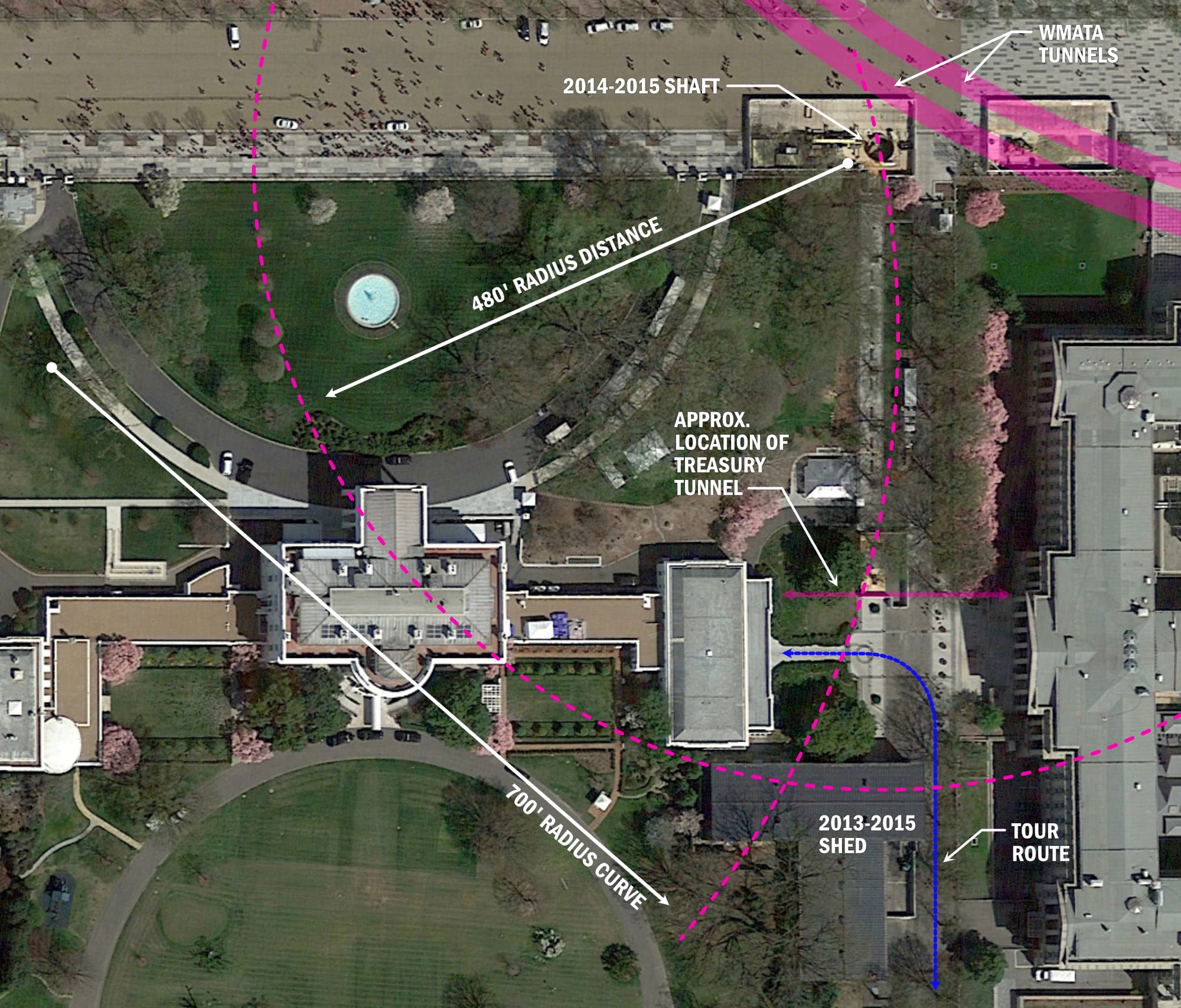
The shaft site was outside of the White House fence and I remember being very curious about what was going on in those two enclosures on the Pennsylvania Avenue plaza. But clearly, I was not curious enough. After all of the very visible utility work on the west side, the government went for extreme secrecy on the east. The report says they were originally considering a more overt approach: a precast culvert closer to the surface. Secrecy went further once they chose to proceed with microtunneling, as "pipe had to be covered prior to the delivery to the work site," stabilizing the ground required grout injection that slowed the boring, and working entirely inside a shed presented a lot of minor challenges.
It is a lot of work to stay discreet, especially for the purpose stated in the report: conveying 4" and 5" electrical conduits. As with all other public communications on the work around the White House, the white paper calls the microtunnel a utility project. Perhaps the government was connecting the PEOC to the public electrical grid in public space, and wanted to avoid drawing attention to this vulnerability (and the PEOC in general). Perhaps there is a connection to metro. It's possible the lower levels of the structure was the new bunker described by Kessler. Or perhaps they were just spooked by the attention the Big Dig attracted.
It's very difficult to say—but it still doesn't explain what was going on in the first shed for seven years before the second one showed up.
Strutting around
Evidence for what was built under the first shed was also visible directly behind the President on May 19th. The first element is a plywood box on the far side of the construction site. The second is the concrete shoring wall that those braces restrain. The third is the large steel struts that cross the pit east-to-west. These all indicate that there is something in the ground that could not be moved.
Aerial imagery from June 2026, at the end of foundation work, shows that the plywood object protects the areaway associated with the first of the two sheds on the east. All of the other openings and areaways visible during site prep in October 2025 are either permanently or temporary covered.
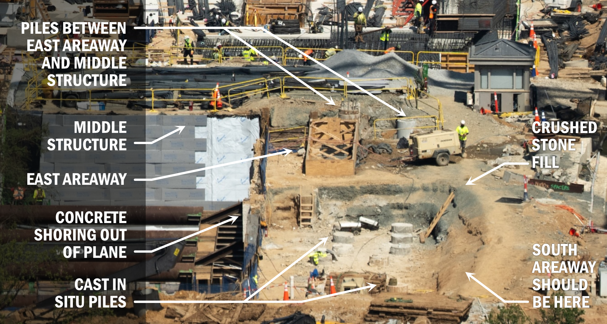
Looking at it from the Washington Monument in April 2026, we see a number of interesting things surrounding the east areaway and its plywood cordon. First, the ground directly adjacent to it has not been excavated. Where it has a few yards away, the subgrade appears to consist of a structural fill like crushed stone. Second, there appear to be large cast-in-place concrete piles on both the north and the south of this unexcavated area. Distinctively, there are none directly in it. This indicates that the structural loads from the ballroom will have to bridge this area—a complication engineers would avoid if they could. Finally, the wall directly west of the unexcavated area is slightly out of plane with the rest of the shoring wall.
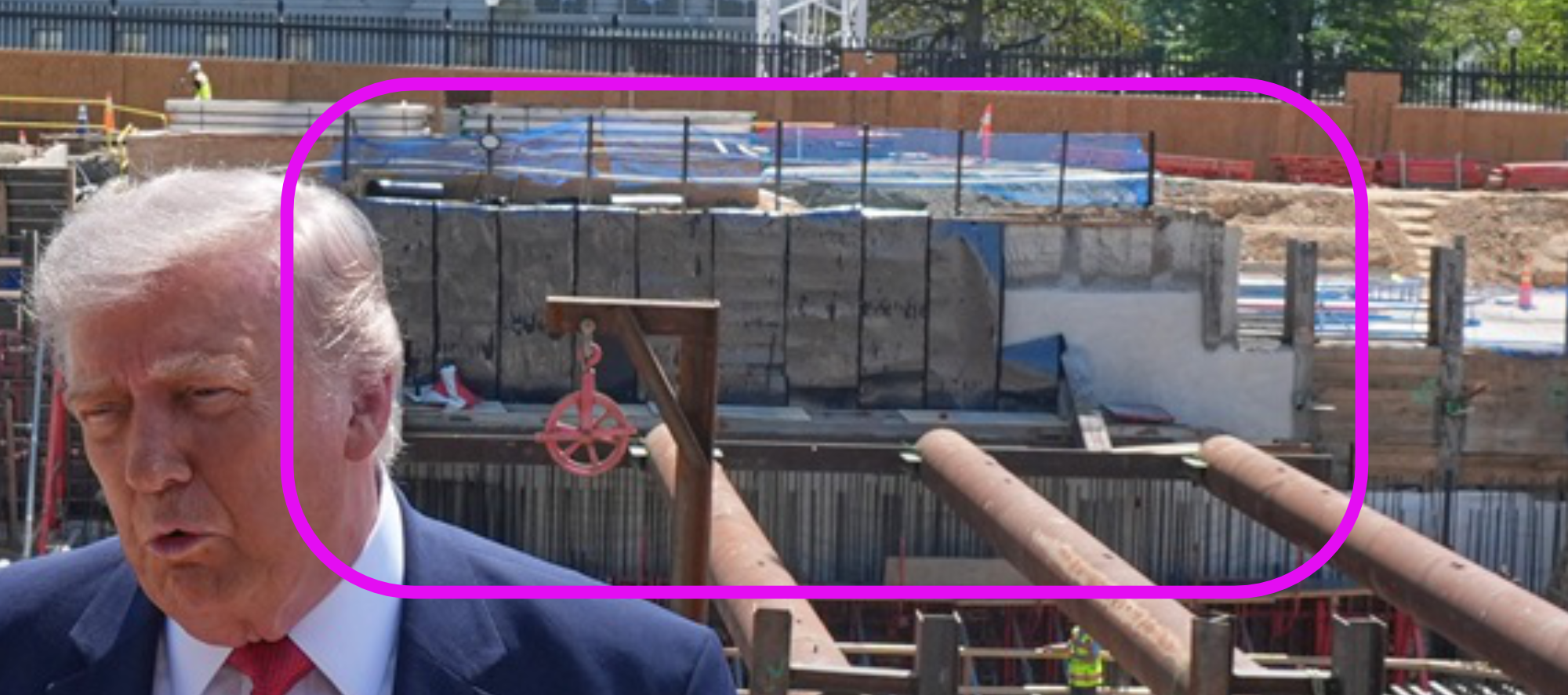
Images of the concrete shoring taken during the May press conference reveal a few other interesting details. First it is clear that it was constructed with soldier piles, like the rest of the walls. However, unlike the rest of the shoring, concrete was poured in between the piles. This is only ever done if the shoring wall is going to be permanent or settlement would damage adjacent infrastructure. In fact, the skew at one end makes me wonder if this section of wall predates the rest of the shoring, that is, if it was already in the ground. It is also interesting that the wall is coated with some kind of cementitious parging, which may serve to seal cracks or smooth out a rough surface. Lastly, I have no idea why bituminous waterproofing is loosely draped over the wall face. Presumably it is being used to protect part of the concrete wall. How much of that protection is from water, how much is from equipment impacts, and how much is from prying eyes like mine: that is much less clear.
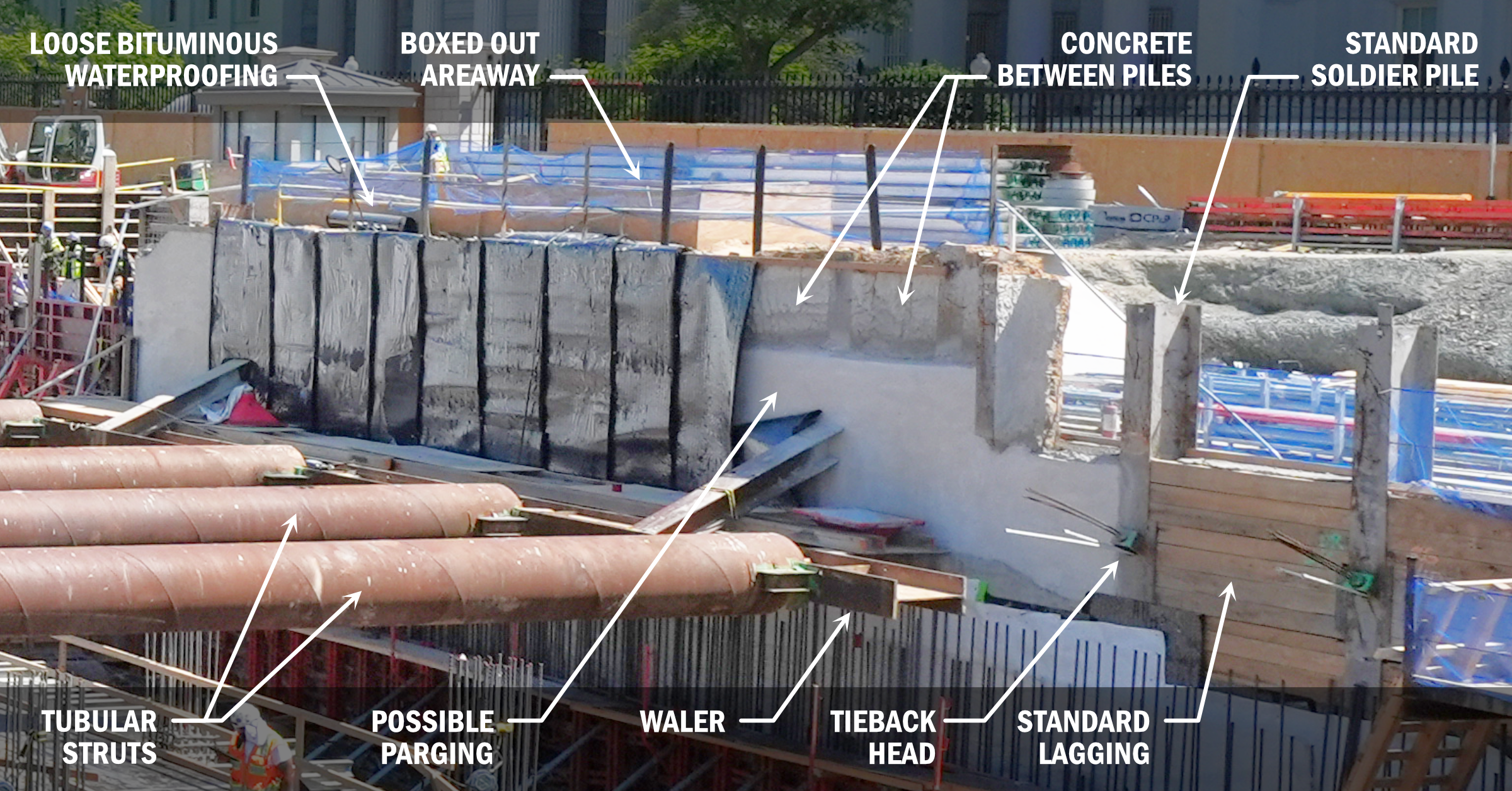
But the most interesting feature in the image are the large tubular struts. As discussed in the Big Dig section, struts are a form of bracing used to support the shoring laterally when tiebacks cannot be used. They get in the way of work, so contractors avoid them where possible. In the image, we see tiebacks on the solider piles directly to the south of the concrete wall but none on the wall itself. Whatever structure is underneath that areaway, preserving it was worth majorly complicating both the excavation and the final building.
Turning to the other end of the struts, on the west side, we see that the entire wall is conventionally shored. There are stains, which are probably from the flowable fill or grout used to stabilize the shoring, but it is not a concrete wall. We can also see that directly to the north of the struts, the shoring steps back to avoid the original PEOC.
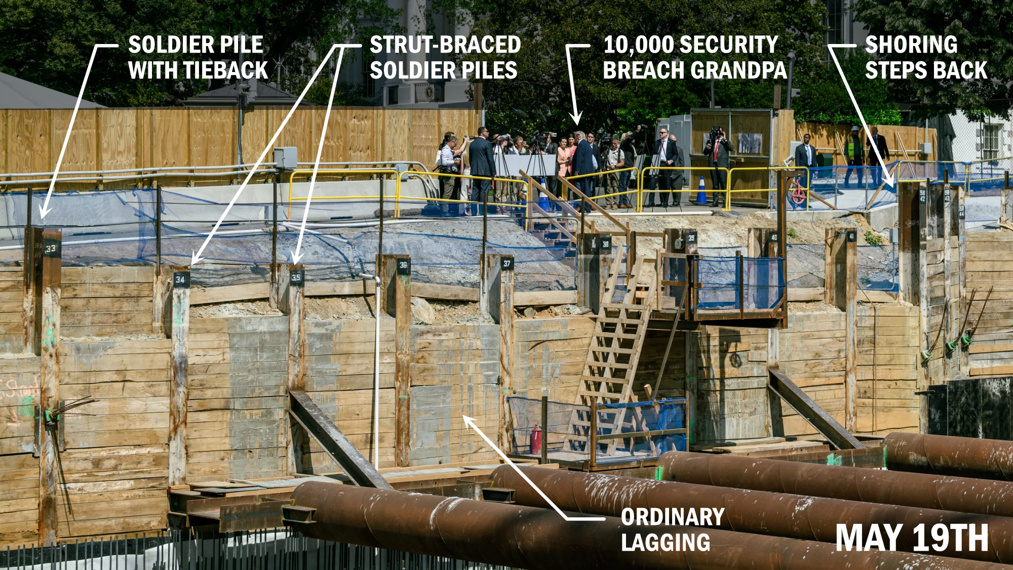
Adding these three clues together, we have clear evidence that during the seven years the first east shed lurked in a corner of Presidents Park, something was built beneath it. Whatever it is, it is important enough to keep intact and operational at significant cost.
The dirt you can't see
Returning to the topic of misdirection, I've come to find the May press conference very interesting. The President stood in front of what is supposedly one of the most sensitive military sites in the country and bragged about its features. But what he did not discuss were the two structures visible behind him. Everything in the bunker was discussed as if it were new. The timing of the presser is also curious. After mentioning that the hole was 50-60 feet deep, he mentioned offhand that two or three stories already been erected. That is, the press was given a grand show only once the lowest levels of the new structure were concealed. Remember that Ron Kessler said that the bunker structure was "five stories" below grade.
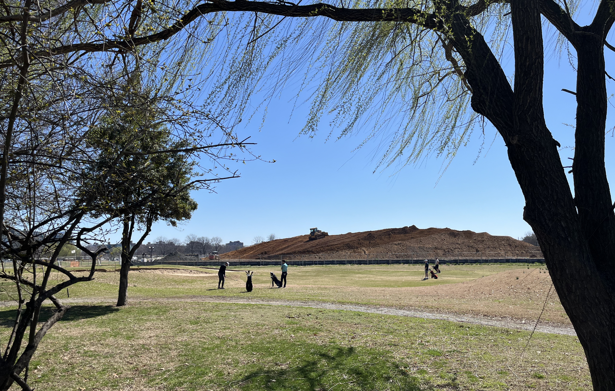
But if that exists, why did they need to build the new one? And if those two structures do run to a new facility, how did they build it? If they built a bunker during the Obama years, where did all that dirt go? Excavating the bunker created a giant hill in East Potomac Park. Was Kessler just making things up?
I don't think so at all. The thing is that I have left off a pretty important fact about the Big Dig and the sheds: both were built by the same contractor. All of the work done around the White House was in fact done by a joint venture of two major construction companies with long rèsumés of secret government work: Clark Construction and the Kiewit Corporation.
Kiewit is one of the largest infrastructure corporations in the world. Privately held, it has world-class experience with infrastructure development, such as building rapid transit, building major pipelines, erecting radar stations in the arctic, constructing hundreds of silos for the Minuteman nuclear missile, and many other things we will never live to hear about.
Clark Construction originated in the DC area and expanded nationally on the back of government work. In addition to having robust ties to agencies that possess sensitive materials, they also have a proven record of sensitivity towards historic structures. That is almost certainly why, in 2024, they won an open-ended contract to perform $500M of work at White House. And it was through that contract that they got the job of building the new ballroom and bunker.
Looking at their respective portfolios, Clark does seem like a natural fit for the kind of work we see around the White House. Kiewit, with its experience in things like tunneling, military bases, and power plants would seem a little overpowered. For a joint venture with both, one would expect to see a much bigger project, possibly with multiple sites across DC.
The thing is, we do see that.
The following section describes secure military sites. Do not attempt to access these facilities.
Imagine a really, really long submarine
The United States Navy has the closest relationship with the Presidency of all branches of the military. The president's doctor is frequently a naval physician. The West Wing kitchen is staffed by naval specialists. The president's vacation compound at Camp David is a Navy base. And the Vice President lives on the secure campus of the US Naval Observatory.
With this in mind, it is worth paying attention to a facility that is known to be highly sensitive, run by the Navy, and built by the Clark/Kiewit JV: the East Utilities Plant.
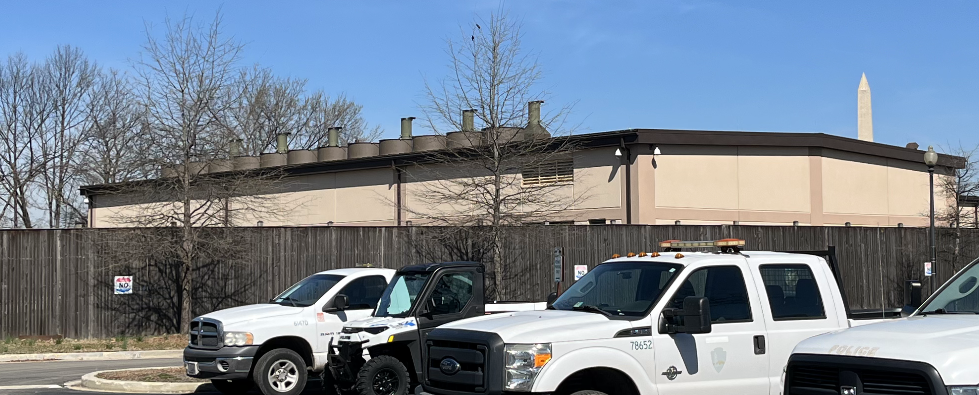
The East Utilities Plant is a nondescript structure tucked between the NPS regional headquarters and the Long Bridge railroad tracks in East Potomac Park. It's tan and it's covered in what looks like EIFS. It could be mistaken for a park service garage, except that it's plastered with cameras, and surrounded by an opaque fence sprinkled with military no trespassing signs. There also appear to be six exhaust stacks sticking up from one roof, adjacent to some other kind of port. If we look at historic aerials, however, we can see that this building just the tip of the iceberg.
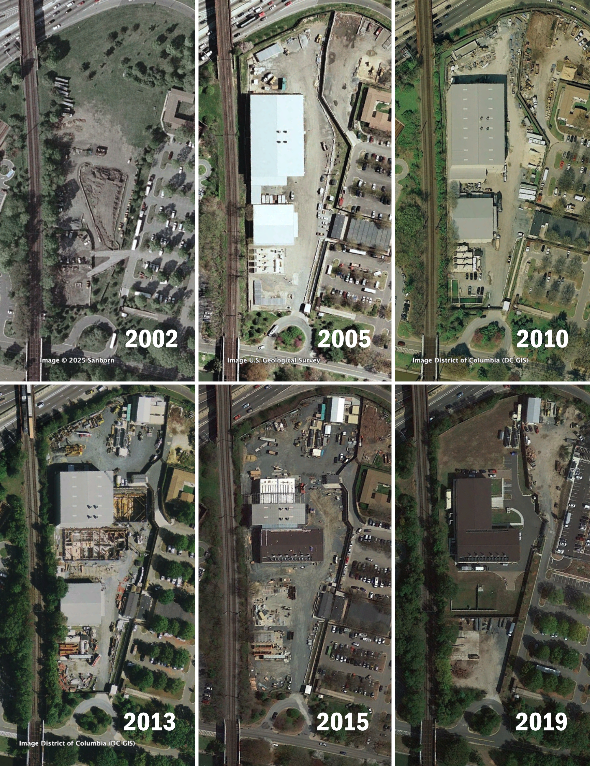
In the 2013 image, we can clearly see a deep structure in the footprint of what eventually becomes the building with exhaust stacks. We can also see a very deep shored pit to the northeast, perpendicular to a prefabricated metal building (or shed) with distinctive white stripes. This shed was erected by 2004 and was shortened to make room for the building with exhausts by 2013, when the two pits were started. Whatever was going on underneath that site was sensitive enough that, as the 2015 image shows, the permanent structure was constructed out of view, fully inside the shed. The Washington Post article above, and other reporting at the time, emphasized the that construction took the design review agencies by surprise, even if they all came around quickly. The articles also noted that the facility saw a steady stream of dump trucks and other heavy equipment, which seems to have lasted over a decade. Where was that dirt coming from?
For that clue, we need to look at the other site identified with the Clark/Kiewit JV: a shed with those distinctive white stripes at the United States Naval Observatory.
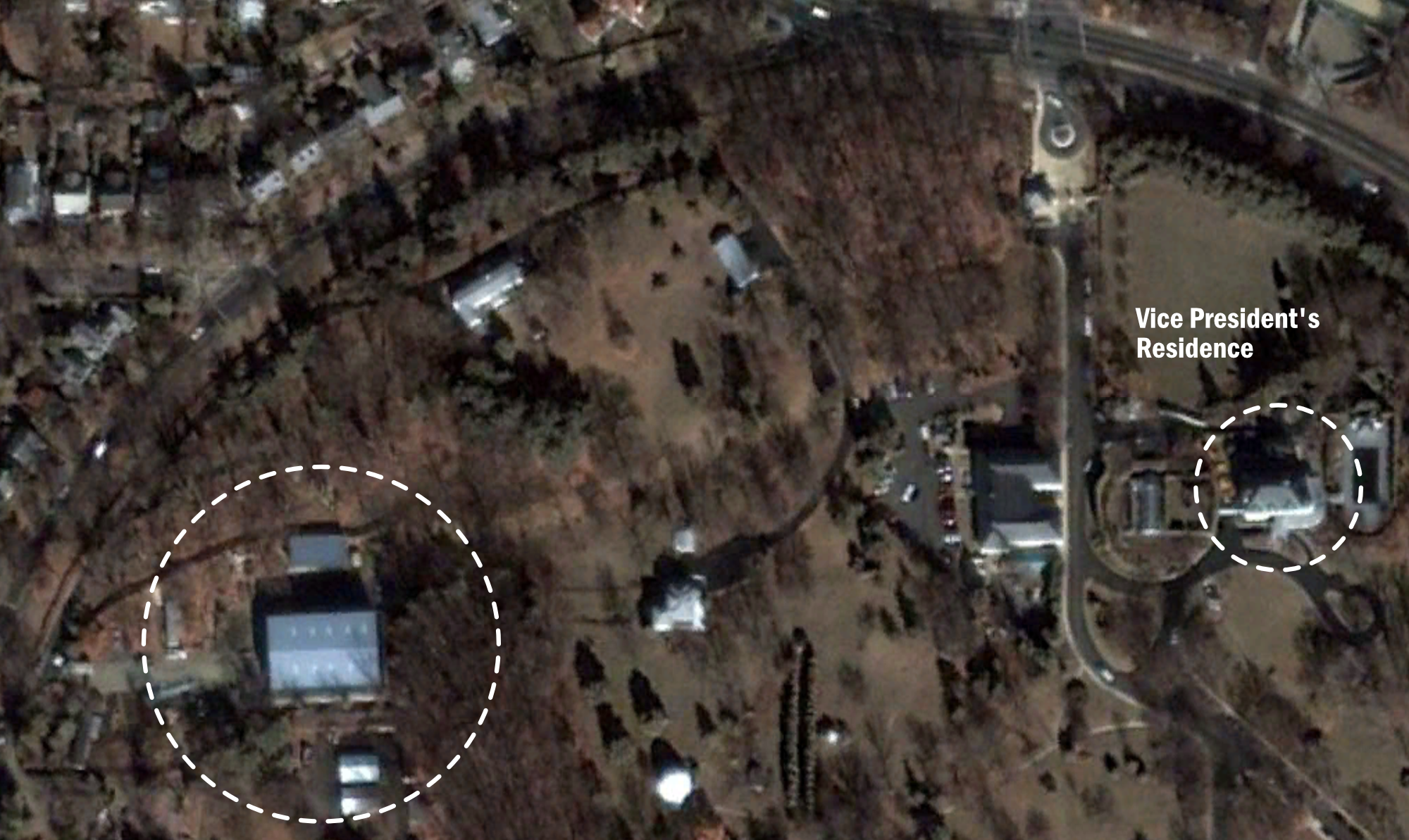
Housed on a perfectly circular campus north of Georgetown, the Naval Observatory provides scientific support to the United States military, particularly in astronomy and timekeeping. It also hosts the residence of the Vice President, who commutes to the West Wing.
The shed structure there had a short but eventful life. Appearing without warning in 2002, it brought hard rock blasting and heavy truck traffic to one of the toniest neighborhoods in DC. The gossip was that they were building a bunker for the Vice President. And then, by 2004 the construction wrapped up, leaving one nondescript structure on the site. In late 2005, a second one was added to its north. The most recent facilities plan for the Naval Observatory says that both structures are "garages that store vehicles for the vice president's security detail." Once again, we have an understated truth that may hide more than it reveals.
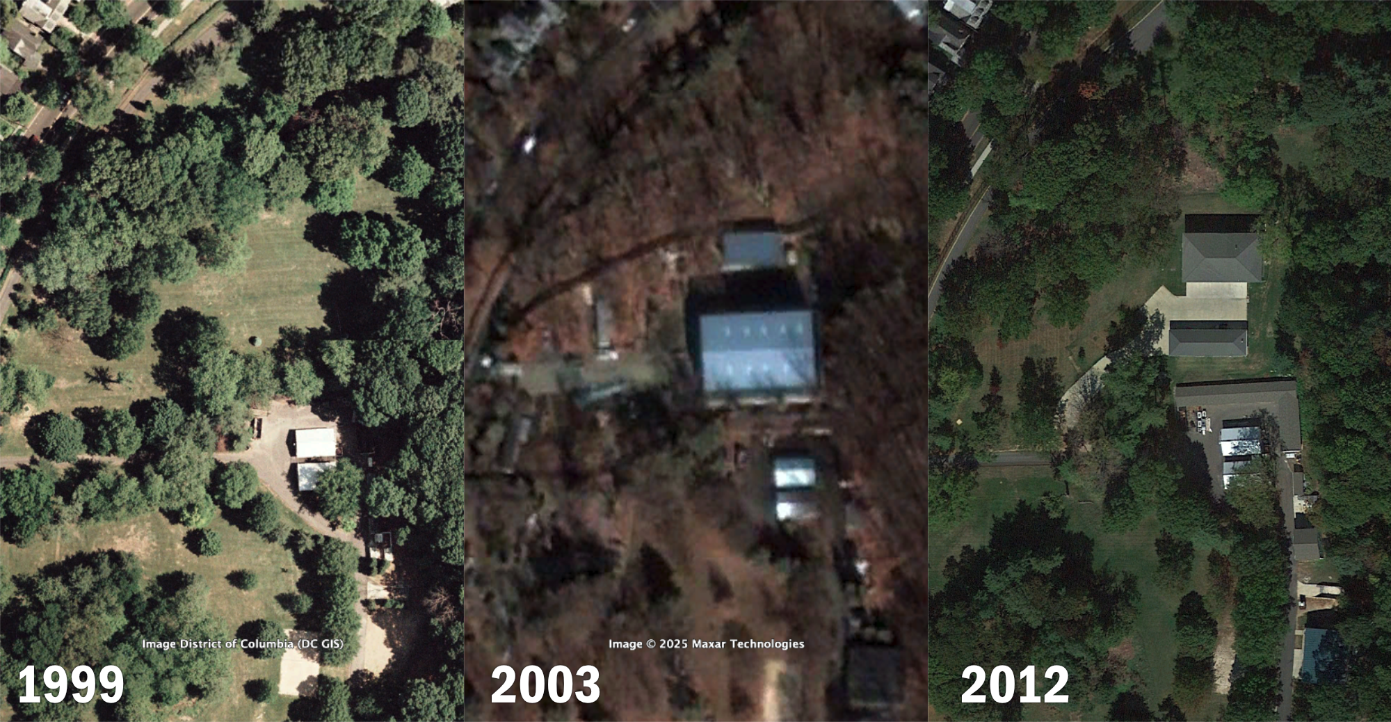
I personally remember both the trucks and the rumors very well. I played sports on nearby fields (and screwed around as a teen in the general area). Unfortunately, I can't get very good imagery from the shed's brief existence. Whatever it is, it seems to have chronological and typological connections to the other mystery sheds.
This becomes very clear if we compare the structures side-by-side. In the image below, I have taken images of the structures at their maximum extent, all at the same scale. I aligned them on the long axis and overlaid a 25' grid.
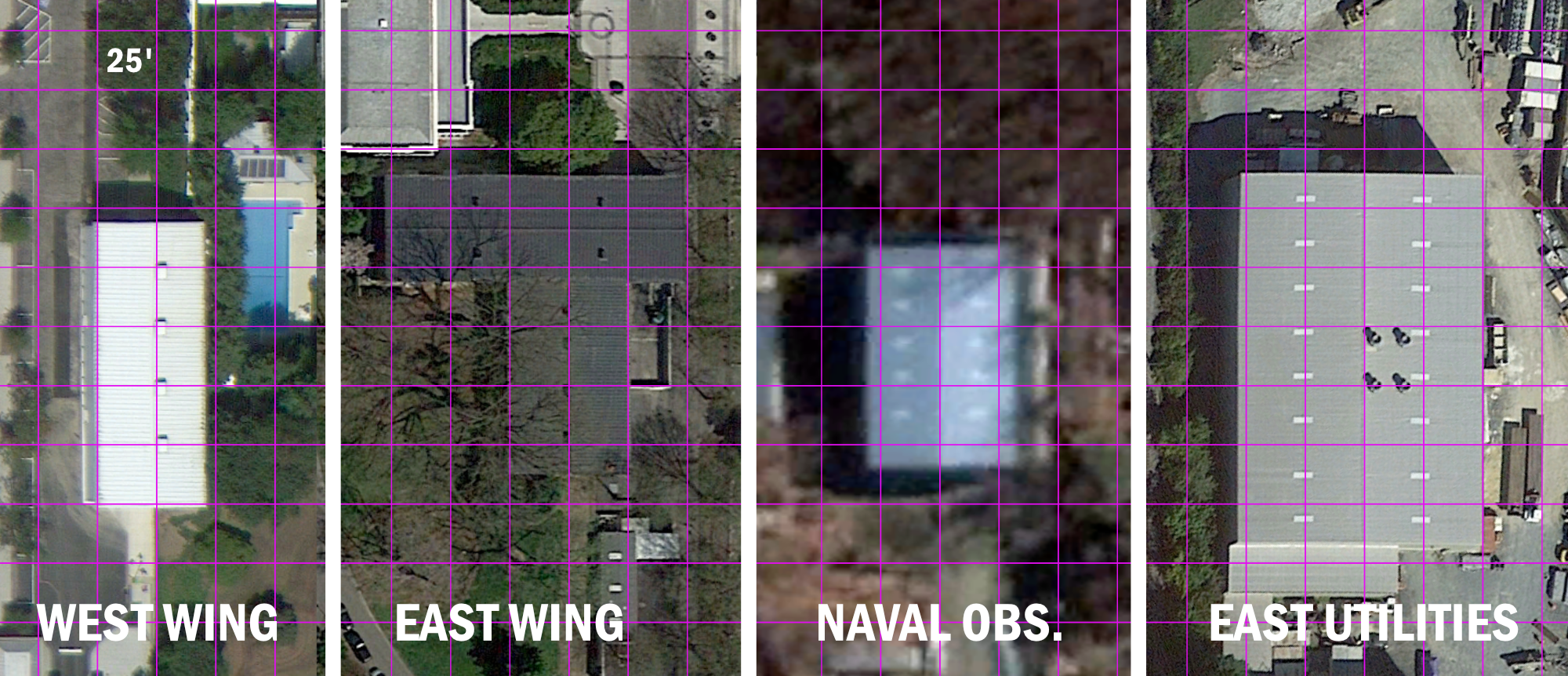
Most of the buildings are 50' or so wide, and anywhere from 80' to 120' long. The northern building at the East Wing, is 50' wide and 120' long. The East Utilities Plant Site was around 100' wide and 150' long at its maximum size. Clearly, this more secluded project is the largest, not even including its multiple temporary outbuildings and eventual underground structure. But how about the schedule?
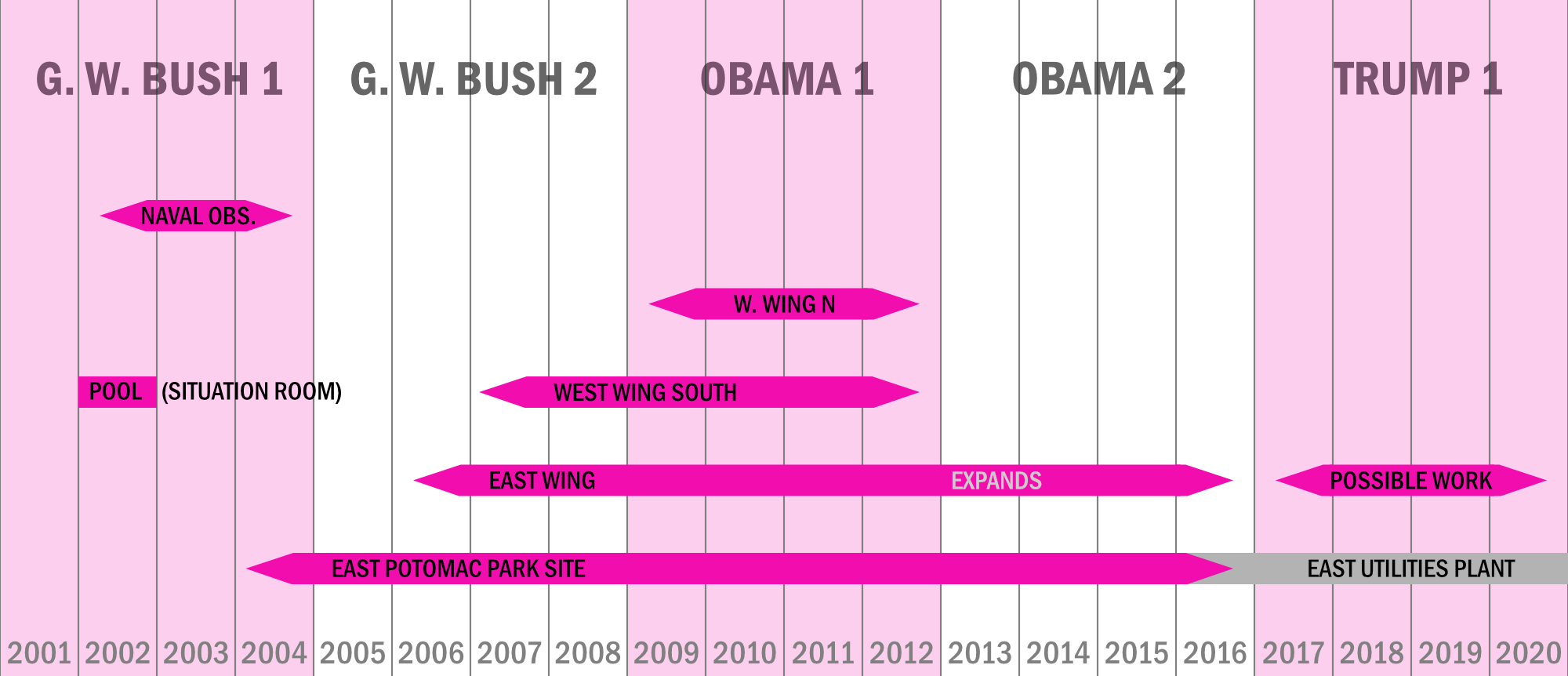
Again, the East Potomac Park site is the most consistent feature of the project. Some amount of construction activity is visible from 2004 to 2016: at least 12 years. The East Wing structure, especially if the Trump-era site work is included, lasted the almost as long. Relative to these long-lasting projects, the two most ballyhooed components of this project, the West Wing north structure and the Naval Observatory element, were under construction briefly. Yes, it is possible these projects include bunkers, but whatever they were doing at the East Potomac and East Wing sites was much more extensive. In fact, there is only kind of project I know of that involves long construction durations and very small surface sites: a tunnel.
Follow the water
Some of the best evidence for a tunnel is water: groundwater, specifically.
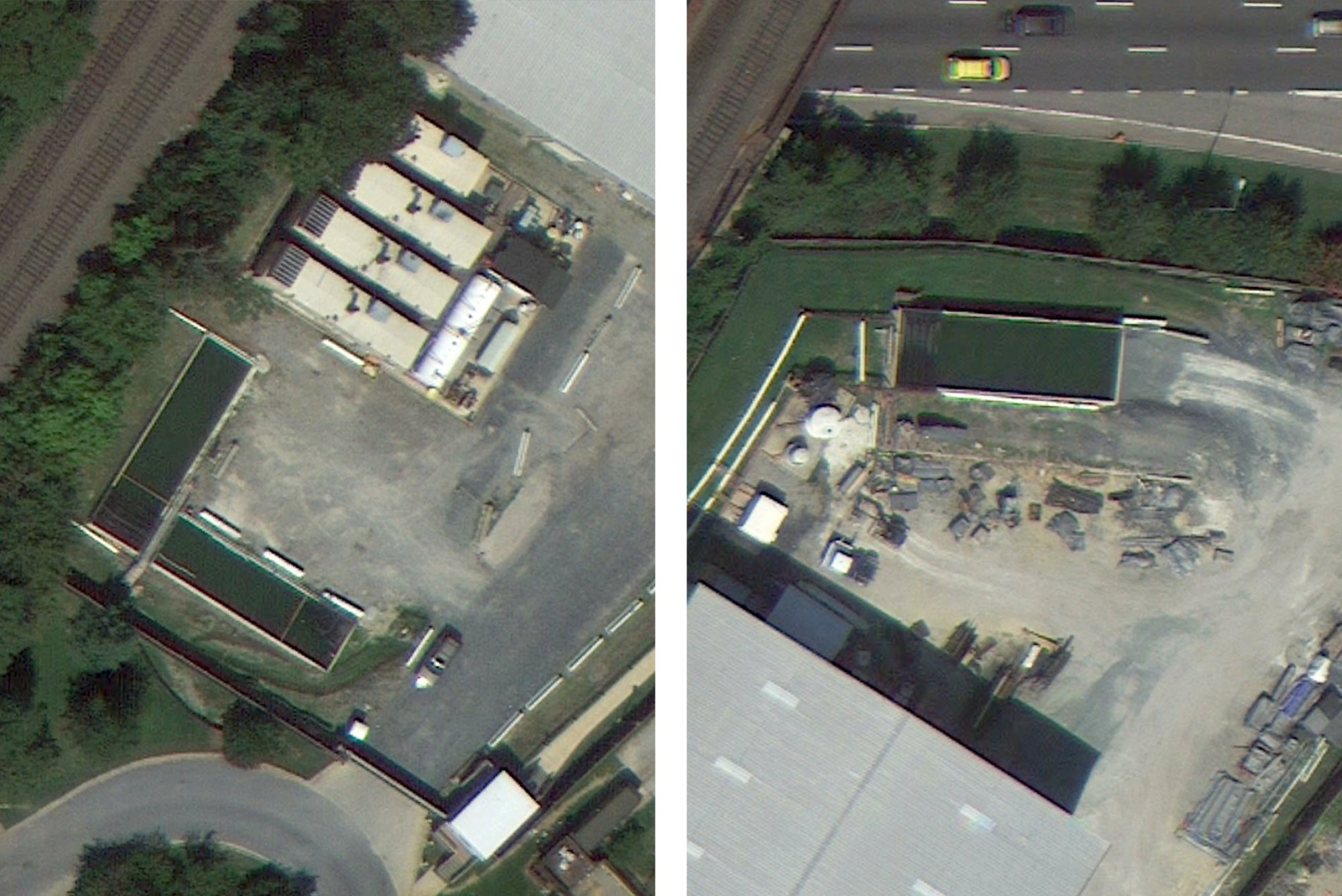
Between 2005 and 2012, three tanks of water sit scattered around the East Potomac Park site. To me, these look like settlement basins, which are used to remove sediments or other contaminants from water before it is released into the environment. They are very common when below-grade construction requires dewatering, i.e. pumping groundwater out to remain dry. Alternatively, they could be used clean the tunnel minings, or "muck." If this is their purpose, then they imply a tunnel was bored with either slurry or earth pressure balance (EPB) tunnel boring technologies, which use pressurized mud (natural or supplied) to temporarily stabilize their cutting face. This wet muck then has to be dewatered and filtered, perhaps with these tanks. EPB TBMs have been the predominant tunneling technology in central DC since the construction of the Green Line under the Anacostia in the 1990s. Beginning this summer, two will be used to bore a large sewer overflow tunnel through the Potomac Parks (notably dodging the East Utilities Plant), so it is reasonable to think one was used for this Navy project.
Irrespective of whether the tanks function for EPB TBMs or just general dewatering, the timing of their appearance in 2005 predates the erection of the sheds at the White House. Their removal in 2012 follows the demolition of the West Wing shed but precedes the expansion of the East Wing shed and the start of the major reconfiguration at the East Potomac site. These dates leave a window of up to 90 months of tunneling and excavation, over seven years. Is that enough time to tunnel the 20-30,000' to the Naval Observatory and do whatever else they were up to?
Relative to the other recent tunneling projects in DC, easily yes. Two 26'-diameter EPB machines were used to mine prior phases of DC's sewer overflow reduction project. One bored the 24,000' Blue Plains Tunnel over 23 months while another bored the 12,500' Anacostia River Tunnel over 12 months. That second machine was rebuilt and used to bore the 27,000' Northeast Boundary Tunnel through more challenging terrain over about 42 months, including a mid-tunnel tune up. So, with average speeds of 640-1040 feet/month, we can estimate that the TBMs would cover the 20'-30,000' distance to the NO in 20-47 months. The 90 month observed window is very comfortable.
(As an aside, I left the fourth, smaller machine out of this analysis, but take a minute to appreciate that they named a giant drill bit that moves slower than a snail after Bloomingdale-area woman and civil rights leader Lucy Diggs Slowe. C'mon!)
A little oopsie
Something else started happening in 2006 that builds the strongest case possible for a tunnel—at least between the East Utilities Plant and the White House.
Now, the western parts of the National Mall (East and West Potomac Parks) are 100% dredged sand and silt. The ground is almost worthless for foundations and prone to movement when water movement is also present. The history of the park is 130 years of settling problems. All major structures in the area around the Mall, like the Jefferson Memorial, rest on heavy foundations driven to bedrock. The pavement and embankments, however, rest on this unstable silt, sand, and sediment. In soils like this, water takes up space and can even modify the molecular geometry of the soil. Removing groundwater from soils like this therefore leads to consolidation, i.e. reduction in volume and therefore subsidence of the surface. If those tanks are settling tanks from a dewatering operation, the water must be coming from somewhere.
Well, in 2006, the National Park Service seems to have noticed the embankments and pavements to the north and west of the Jefferson Memorial (and even the building itself) were shifting and sinking. The west flank of the memorial area had always experienced some of the most severe settling around the Tidal Basin, where by 2002 high tide routinely overtopped the embankment, creating the famous dwarfed Cherry Blossom tree known as "Stumpy." The subsidence in 2006, however, was abrupt and rapid, affecting areas that had previously been stable. In geotechnics this is an emergency situation.
NPS commissioned reports and quickly secured money for major repairs of the area directly in front of the Jefferson Memorial. The rush to fix a surprise problem attracted the attention of DC's many watchdogs, busybodies, and gadflies. Their suspicion grew when NPS declined to release some of the project documents that were expected for design review. Eventually, one group retrieved and published documents using a Freedom of Information Act request. This included a geotechnical analysis by Schnabel Engineering, a well-established firm. And this, I think is the smoking gun for the tunnel.
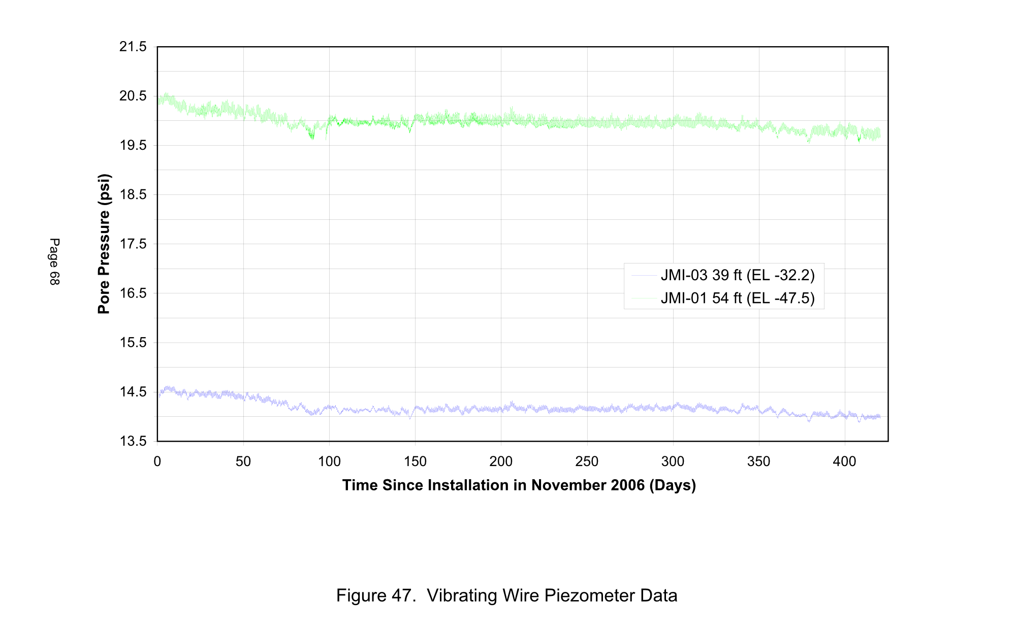
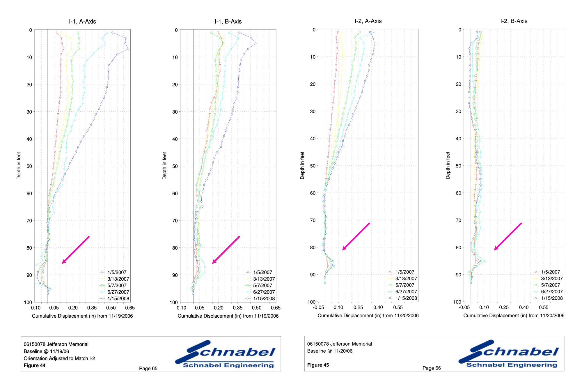
I am not a geotechnical engineer, but I can understand the gist of a geotech report. Figure 47 shows a two-stage drop in "pore pressure," a measure of the hydrostatic (still) pressure of groundwater in a given soil. Drops in pore pressure are common when groundwater is being pumped out of an area, usually construction below the water table. As discussed above, this can lead to consolidation, and therefore the kind of subsidence that manifested around the Jefferson Memorial. These results are expected on construction sites that involved dewatering, requiring close monitoring to avoid damage to adjacent areas. Schnabel was unable to explain these drops with natural phenomena.
The other telling observation comes from inclinometers, which measure the displacement of a pipe drilled into the ground. The charts provided in Figures 44 and 45 show not only a severe shifting to the northwest close to the surface, but also a separate and very distinct displacement between 80 and 100 feet below grade. Again, I am no expert, but this is very unusual to encounter in ordinary foundation work. Based on research, the dynamics and shape of this movement appears to be consistent with displacement caused by tunneling. Instrument I-1 is to the west of instrument I-2, suggesting that a structure to the west of the memorial might be even deeper. Notably, the report's narrative does not describe this lower stratum of displacement and simply moves on after noting that natural dynamics cannot explain what is happening.
To be honest, I am surprised they released these figures at all; other parts of the report were redacted. Could it be disinformation meant to fool people like me who think they're savvy? Maybe! Welcome to the hall of mirrors. On your left you will see John le Carre and Graham Hancock in a hot tub; the Vatican Supercomputer is at the end of the hall.
It's an infrastructure project
I have been following this for fun since 2010, and ultimately, I have to hand it to the Navy. They did a good job of keeping whatever they did under wraps. I have asked government officials about the project, and while the way they told me nothing told me a lot, they still, at the end of the day, told me nothing. I suspect most of them had deduced what I have, but don't know really know more. What I outline above, to be clear, is the best I could do with information on the web: aerials, documents, posts, and websites. It is what they could not hide or wanted us to see, including the allies and adversaries of the United States.
All that I can do is speculate with my professional experience, historical knowledge, and this research. I will not pretend to have figured everything out. In fact, until Trump's remarks on March 29th, 2026, I assumed the entire project was completed in 2016. But combine that information with Clark's massive 2024 contract, and maybe that GSA rep was telling the truth in 2010 after all: there was an East Wing phase yet to come.
I suppose the only thing left to do is try to synthesize all of this information. This will be more speculative. Take it with a large grain of salt.
Let me bake:
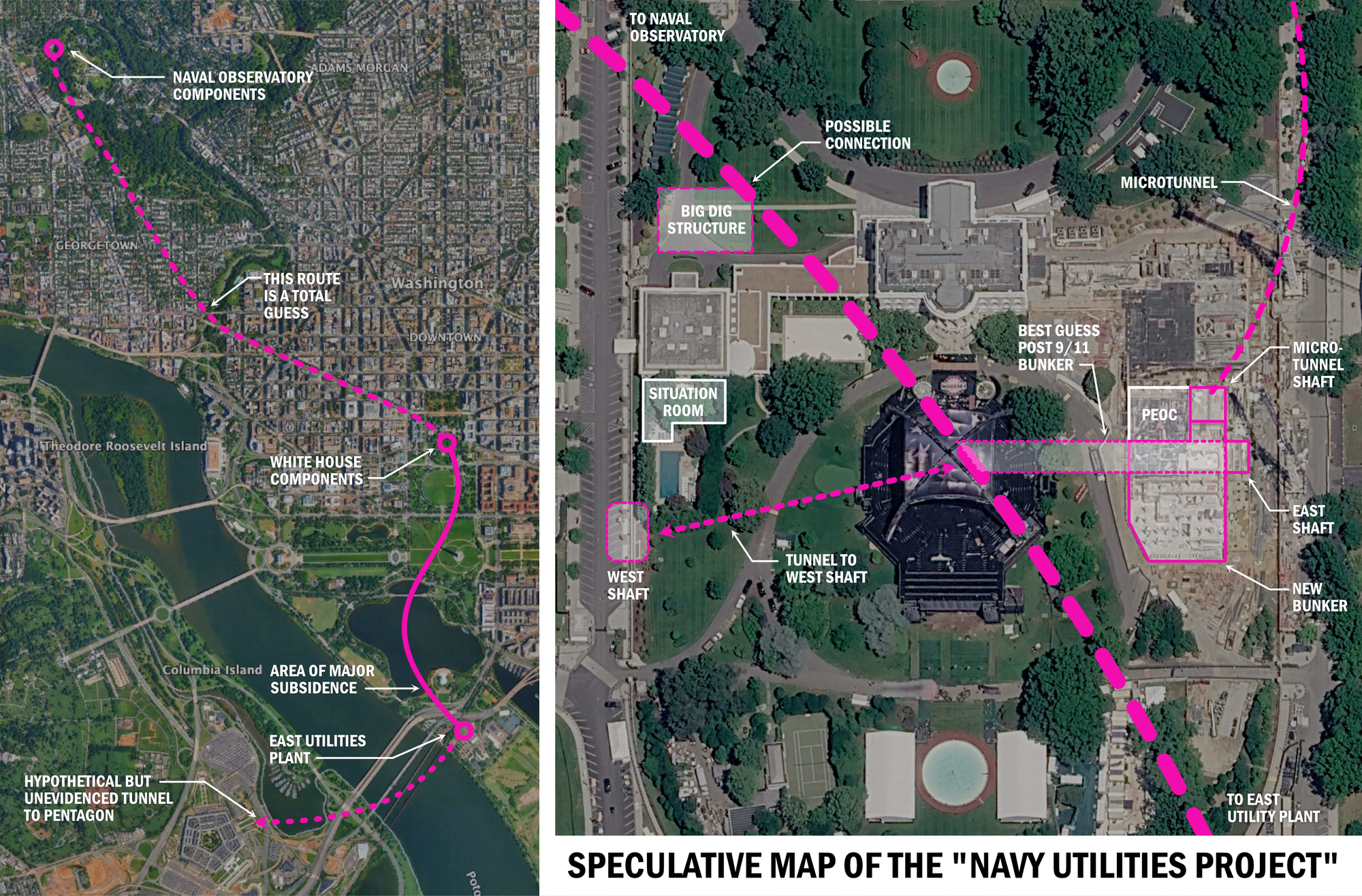
Between 2002 and 2016, the Navy built a tunnel from East Potomac Park to the White House and the Naval Observatory. Utilities around the White House were significantly upgraded and some kind of shelter was built under the White House grounds. Some kind of facility was likewise built near the Vice President's house. Supporting both of these locations (and possibly more) is the the East Utilities Plant. The bunker they are currently building is the latest and possibly final stage of this massive continuity of operations project.
The purpose of the tunnel, the EUP, and all the work around the White House is exactly what federal officials have always said it was: infrastructure. It's just that these specific pieces of infrastructure ensure continuity of government during major crises. One of its purposes is the physical safety of the leadership of the Executive Branch. Its principal function, however, is supplying key facilities with secure power, telecom, water, gas, and who knows what else. The multiple facilities and extensive connections mean that the system is redundant, resilient, and decentralized. Even though none of this would survive a nuclear strike, that has not been the threat model since at least 9/11.
Additionally, using a tunnel to construct as much of this system as possible means that it remains relatively secret. As much evidence as I have pieced together here, we just cannot glean most of the important information from public sources.
For example, we don't really know what is at the East Utility Plant. The exhaust stacks poking out of its roof certainly look like diesel generators to me. But the only things that looks like intakes are the adjacent, shorter cylinders. They're unusual. Everything else is speculative. There is probably electrical switching equipment and tanks for supplies like diesel and water underground. It seems likely that there are utility connections to the Red Line tunnel and at the Naval Observatory, but there is no way to know exactly. The 7' diameter of the microtunnel suggests it is not meant for evacuation.
Similarly, the extensive use of sheds means we can only guess at how the system was constructed. Clearly, the East Potomac Park complex was used to launch one or more tunnel boring machines and remove mined spoil. The sheds at the Naval Observatory and White House concealed the connections from this tunnel to existing infrastructure. If the tunnel ends at the Naval Observatory, the TBM was either buried in place or dismantled and brought back through the EUP. The structures are too small to accommodate the kind of heavy lift crane required. If there is direct connection to the Vice President's house, it was carefully concealed, and probably mined from below.
If this is true, it's possible that the tunnel runs to many other locations, including the Pentagon. Certainly, the Pentagon was gut renovated between 1998 and 2011—in addition to the total rebuild of the section destroyed during 9/11. If a shaft similar to the one built at the Naval Observatory was constructed, it could have been concealed in the renovation, even occurring under the existing building itself. However, I don't see evidence of it.
Even the route of the tunnel is difficult to discern. From the geotechnical reports and just tracing a route to the White House, we can assume it passes near the Jefferson Memorial. Specifically, I think it runs to the monument's west, in the area around that was recently reconstructed due to severe subsidence. This is where the famous cherry blossom tree "Stumpy" once stood. The route from the White House to the Naval Observatory is harder to discern. There are a number of routes it could take once it gets away from the White House, but downtown, it seems relatively constrained. I see one clue: that unexplained angle in the ballroom's foundations.
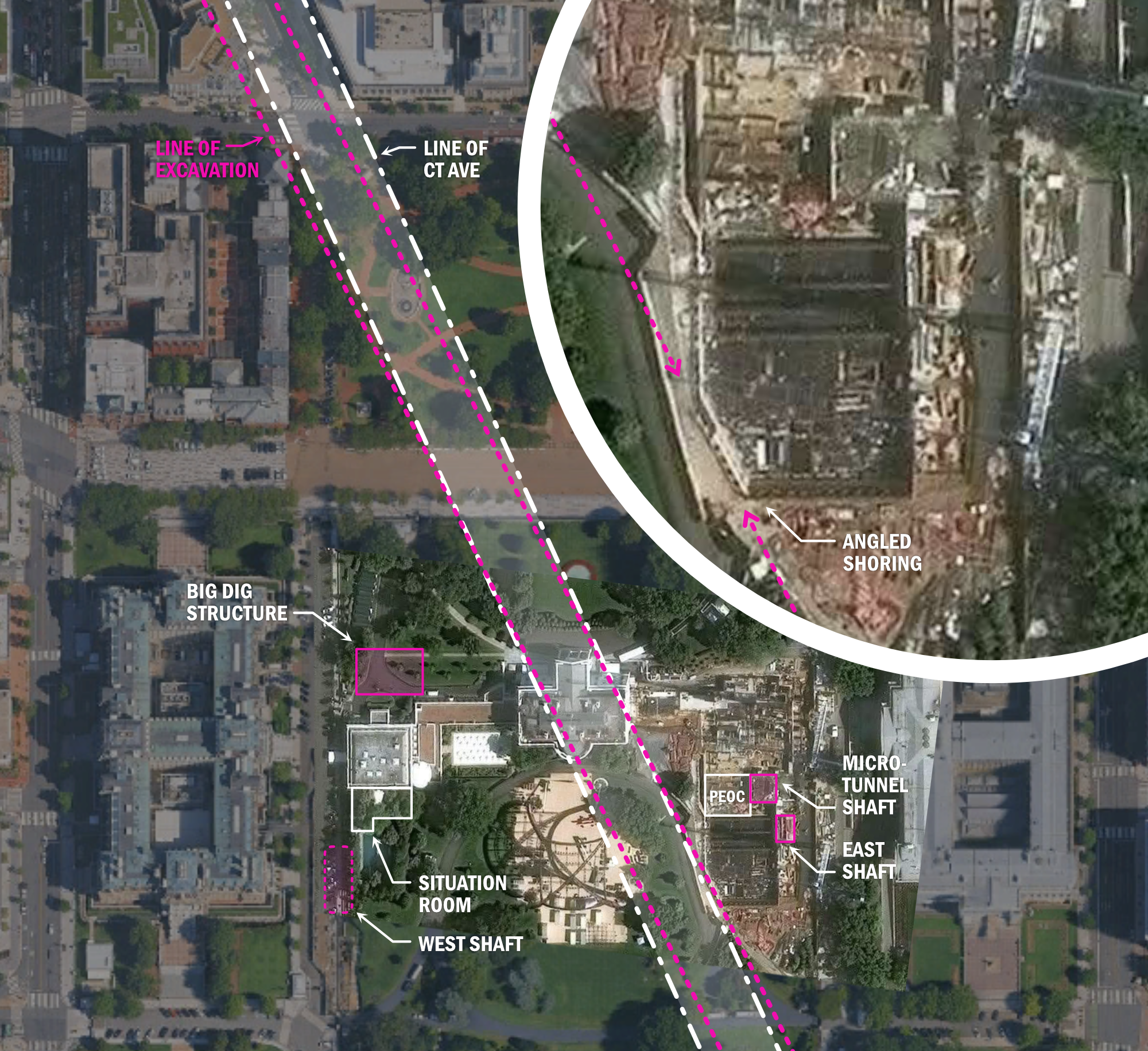
Tantalizingly, it comes very close to aligning with the path of Connecticut Avenue. This vexes me. If the tunnel does run up Connecticut Avenue, this would mean it runs underneath the metro's Red Line, probably until at least Dupont Circle. That station and adjacent tunnels are famously deep. It would also mean that the tunnel runs directly underneath the historic Executive Mansion itself. Both of these would raise the costs and risks of the project dramatically. Consequently, I find it hard to believe the tunnel takes this route. On the other hand, I do think the foundation is notched in order to not disturb the tunnel and possibly the facility that Kessler describes.
Finally, building underground also means we are also mostly in the dark about anything built along the way, particularly at the White House. All evidence points to connections between deep and shallow infrastructure at the east and west sheds. Certainly, the structure constructed just east of the old PEOC is more than just an electrical room, and is being connected to the massive Trump-era bunker.
The relatively shallow Big Dig structure, on the other hand looks like it mostly functions as a utility space, just as GSA said. It sits directly east of the cooling towers located in the courtyard of the Eisenhower Executive Office Building and was constructed just a few years later alongside extensive utility work in West Executive Avenue. It is similarly close to the Truman-era utility tunnel that runs on the north side of the White House. I suspect that this structure contains prosaic but much-needed building systems—and probably servers, a building system no prior project would have left enough space for. Maybe even a data center...
So, returning to the start, I admit that is possible that there is an entrance to the tunnel or even post-9/11 shelter via North Lawn. But it is not the bunker itself. The facility Kessler describes is either the addition to the PEOC, or something much deeper still.
Put it all together, taken with premium, high-orgone Himalayan pink salt:
Oh, and uh, does the tunnel contain a full size train system that allows VIPs to move around DC during a nuclear war, like Moscow's Metro-2? No, of course not, this was funded by the Bush Administration. It's Bus Rapid Transit.
How does the ballroom fit into this?
Per the GSA rep's comments from 2010 and Trump's from 2026, I believe that whatever continuity of operations work is being done as part of the ballroom project, it has been planned since about 2001. The big, new structure may be the final part, or it may only be yet another step in a long-running plan. The $500M contract with Clark that preceded the single-source Trump contract points to a more complicated origin story for the Ballroom than just Trump's whims. Certainly, this new continuity of government facility is not his idea.
If I were a journalist investigating this story, I would look into the following:
- Was the bunker project initiated by Dick Cheney? As Gerald Ford's Chief of Staff and then Secretary of Defense under both Presidents Bush, Cheney led development of continuity of government protocols and facilities. Did his experience on 9/11 spur him to finally implement one of these schemes?
- Did Trump's decision to build the ballroom trigger this long-awaited phase of the project, or did the military talk Trump into building a ballroom so they could complete their security facility? If it is the latter, they got the same outcome as all the other people who have tried to use Trump to advance their agenda. After going to extraordinary lengths over decades of work to draw as little attention to the sensitive project, the President can't stop talking about it. What a twist.
What about other theories, like a data center?
I want to emphasize the mundaneness of this project. After 9/11, the government determined that the White House needed a safe place for the President to hide in an emergency and it needed secure utilities. Even when Trump runs his mouth about this project, he emphasizes the importance of protecting himself and other VIPs (people he hangs out with). What the White House does not need is an "AI data center." If that sounds plausible to you, this is a wakeup call. Clean up your information environment ASAP. This makes no sense, and I hate that I have to explain this—and I just wrote 8,500 words of crankery.
Now, there will no doubt be some kind of data frames and all manner of secure communications systems in the building. The White House is full of equipment whose purpose is strictly need-to-know. The DC area is full of secret facilities, SCIFs, gray sites, fronts, and on and on. Northern Virginia is a hub for data centers because three-letter agencies were massive early uses of the internet, and there are hardened fiber lines all over the place. So, until David Icke tells me where in the Gulf of Arabia I can find the Annunaki command center, I will assume DC is the spookiest place on the planet, full of "electrical closets" the janitor can't open.
But what I as an architect do not see is sufficient mechanical backend for some kind of 40,000sf autonomous AI server farm. The drawings do not show the kind of spaces required for rejecting the enormous amount of heat generated by data centers. Unless they are using an exotic HVAC system they don't even use at the the NGIA campus or NSA Utah facility, they would use cooling towers that need to exhaust to the open sky, and take in air from large areaways on all sides. Usually in data centers, these are fully outside the server enclosure or in exterior "wells" within the outer walls.
Similarly, there is no reason to place a critical data center underneath the biggest target on the planet. In fact, everything I've read about federal continuity of operations says they want to scatter critical infrastructure. The president's person is one of the few things that has to be at the White House. The idea that Trump is building a data center stems from the same presumption that he must have some plan, and that his lawless authoritarianism is systematic, when it is not.
I think it is more likely that Donald Rumsfeld built a portal to the Hollow Earth than that they're building an "AI data center." I think it is more likely that there is a crystal chamber where Susan Wiles goes to channel Atlanteans than that they are building an "AI data center." I thin it is more likely that the real Hillary Clinton is in a hibernation pod in the East Utilities Plant than that they are building an "AI data center." I am begging you, please try to figure out how the government actually thinks about continuity of operations and what data centers actually do.
In conclusion, I personally believe that intelligence agencies spread conspiracy theories to discredit nosy individuals and misdirect the public from merely secret activities. We know that UFO theories were promoted in order to conceal aircraft development: classic disinformation. In fact, I accept that what I take as evidence may be disinformation. So take all of this with a grain of salt.
Post-confirmation addenda
In this section I will address aspects of the Navy Utilities Project that have come out since the Washington Post confirmed the existence of the deep continuity of government facility.
How deep is the White House facility?
Sources cited by the Washington Post say that the bunker is:
- "buried more than 60 feet underneath the White House"
- "buried deep into the Washington bedrock"
- "built to withstand a nuclear blast"
These claims are all possible, but they require careful evaluation, both in terms of understanding the project and understanding subtle disinformation. The reason is that the three claims do not add up cleanly. Either it is not in bedrock or it is way more than 60' underground—especially if it truly can survive a direct strike by a thermonuclear weapon.
If it is really able to survive a strike by the ballistic missiles of a peer adversary, like China or Russia (supposedly), then we are talking about a facility much closer to the DUCC. This scheme required a complex thousands of feet below grade, with a seismic shock system to prevent, I imagine, all the vacuum tubes from shattering in the blast. Maybe the threat model was different in 2001, and they were thinking about asymmetric weapons like briefcase nukes or dirty bombs. I don't know, and I am not qualified to evaluate exactly what level of protection this facility can actually offer. So I will just leave it with a note to be careful about taking claims at face value.
That brings us back to a question I can address: how deep below the face of the earth is this thing?
The depth of bedrock in urban areas is a well-studied subject because it is so important to foundation design. DC is no exception, and in ground underneath original 1793 limits, or "L'Enfant City," solid rock is usually pretty far down there. On a macro scale, this is because it is where the lowest shoulders of the Appalachians (the Piedmont) dips abruptly below an accumulation of densely packed sediments (the Coastal Plain). Therefore, in downtown, commercial buildings almost never excavate until bedrock. The soils are sufficient for our expectations of a building's lifespan. The recent monuments which are built on landfill with the texture of soft tofu and need to last for generations, are anchored in bedrock. The WWII Memorial has a particularly solid foundation. The Washington Monument, on the other hand, has been YOLOing since 1848. (You can read about all of this in this paper.)
The point is: if we can look at the baseline geological survey for the DC area, we quickly see that one of the two remaining claims can't be right. This report, published posthumously in 1950 by federal geologist Nelson Horatio Darton, collated decades of borings, surveys, and observations. The survey's Plate 2 shows us what we want to see: observed and estimated bedrock in central DC. There are three forms of data on the map:
- Dots with numbers next to them. These indicate the location and maximum depth below the surface of that location, that was drilled by a borehole.
- Thick black lines, which are estimated contours of the depth of the surface of bedrock below an official definition of sea level, or datum.
- Finally, it shows fields of different green hatches. Each of these shows an estimated depth of bedrock below surface at a given location, based on measured elevations topside.
The final thing to understand is that the ground floor of the White House is supposedly around 50' above sea level.
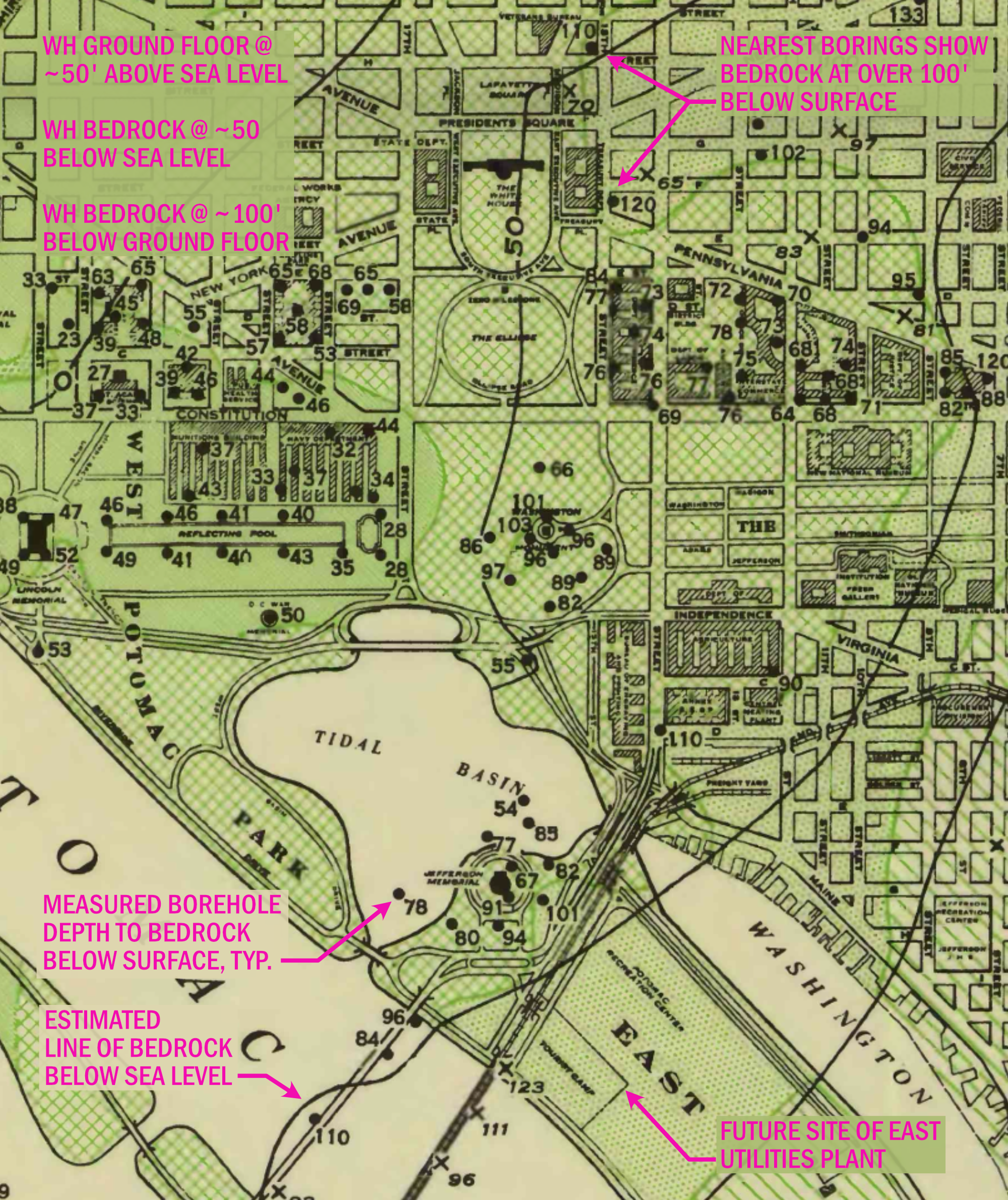
The particular diagonal cross hatch shown at the White House indicates that bedrock sits between 50'-100' below the surface. At first glance, that may seem to match up OK with the "five or six stories" or "more than 60 feet" claims made by the post. With a little more thought, we see that either that "more" is a load bearing adjective, or this thing is kind of surfing on the bedrock.
The reason I say this is that the contact between rock and soils is an engineering challenge. Differential materials move differently while groundwater often travels along the contact surface. For these, and other geological reasons, the top thickness of rock is often heavily fractured or "weathered." It is not somewhere you would want to build something. When buildings are built on bedrock, this layer is either removed or stabilized by injecting grout. Pilings are likewise driven at an engineered force that corresponds to the future structure's loads until "refusal." What is for certain is that you wouldn't want to embed a structure in this unpredictable liminal condition.
So either, the facility is solidly in the bedrock, and therefore well below 60' below the ground, or it's above the bedrock, 50'-60' below grade. Personally, I am torn on this issue. 50'-60' is the number we get from Kessler and it's also the depth given for the new excavation. If these people (whose understanding of construction technicalities is unclear) are repeating something that originally meant 50'-60' below the subbasement of the White House, that could kinda put the bunker into bedrock, but not by much. On the other hand, hard rock is also over 100' below the surface at the East Potomac Park, suggesting that that is closer to a the actual depth of the tunnel, assuming it is relatively flat. After all, we do see the inclinometer anomaly in sediments at approximately 80'-90' below the Jefferson Memorial seawalls, just below the identified elevation of rock surface in Darton's map. Perhaps beyond my knowledge.
Last updated 8/29/26.